You are here: Home > Network List > IW - Intermountain West Stations List
> Station DLMT Dillon, Montana, USA > Earthquake Result Viewer
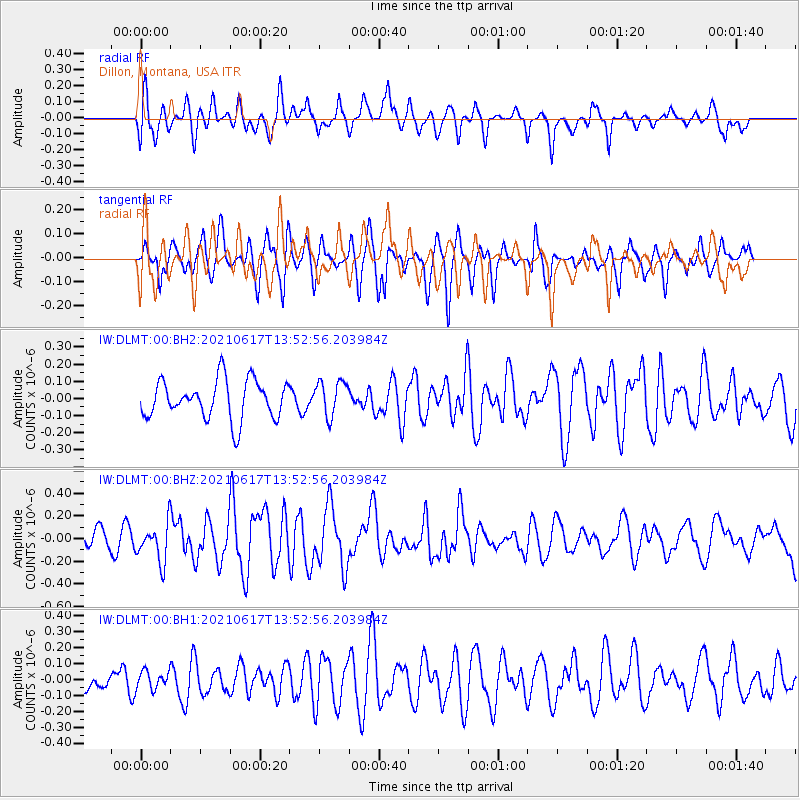
DLMT Dillon, Montana, USA - Earthquake Result Viewer
*The percent match for this event was below the threshold and hence no stack was calculated.
| Earthquake location: |
Tonga Islands Region |
| Earthquake latitude/longitude: |
-17.2/-172.8 |
| Earthquake time(UTC): |
2021/06/17 (168) 13:41:03 GMT |
| Earthquake Depth: |
10 km |
| Earthquake Magnitude: |
5.5 mww |
| Earthquake Catalog/Contributor: |
NEIC PDE/us |
|
| Network: |
IW Intermountain West |
| Station: |
DLMT Dillon, Montana, USA |
| Lat/Lon: |
45.36 N/112.60 W |
| Elevation: |
1569 m |
|
| Distance: |
82.8 deg |
| Az: |
38.07 deg |
| Baz: |
236.705 deg |
| Ray Param: |
$rayparam |
*The percent match for this event was below the threshold and hence was not used in the summary stack. |
|
| Radial Match: |
66.228294 % |
| Radial Bump: |
400 |
| Transverse Match: |
73.86032 % |
| Transverse Bump: |
400 |
| SOD ConfigId: |
25131211 |
| Insert Time: |
2021-07-01 14:09:14.652 +0000 |
| GWidth: |
2.5 |
| Max Bumps: |
400 |
| Tol: |
0.001 |
|
Signal To Noise
| Channel | StoN | STA | LTA |
| IW:DLMT:00:BHZ:20210617T13:52:56.203984Z | 2.0224712 | 1.7219895E-7 | 8.5142844E-8 |
| IW:DLMT:00:BH1:20210617T13:52:56.203984Z | 0.51303786 | 5.574599E-8 | 1.08658625E-7 |
| IW:DLMT:00:BH2:20210617T13:52:56.203984Z | 0.9050161 | 1.0210953E-7 | 1.128262E-7 |
| Arrivals |
| Ps | |
| PpPs | |
| PsPs/PpSs | |


