You are here: Home > Network List > TA - USArray Transportable Network (new EarthScope stations) Stations List
> Station TUL3 Leonard, OK, USA > Earthquake Result Viewer
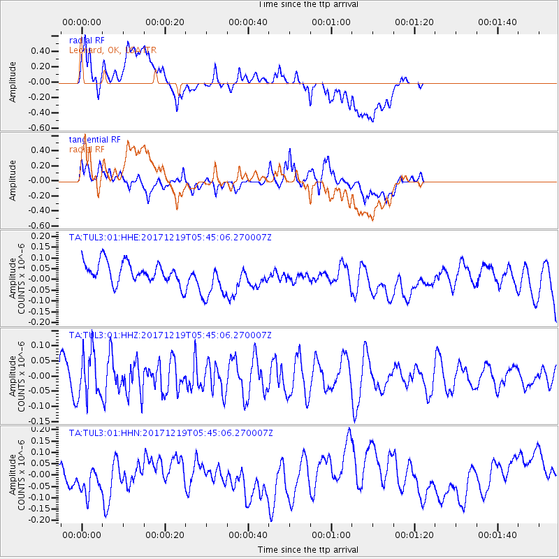
TUL3 Leonard, OK, USA - Earthquake Result Viewer
*The percent match for this event was below the threshold and hence no stack was calculated.
| Earthquake location: |
Southern East Pacific Rise |
| Earthquake latitude/longitude: |
-21.9/-114.2 |
| Earthquake time(UTC): |
2017/12/19 (353) 05:35:29 GMT |
| Earthquake Depth: |
10 km |
| Earthquake Magnitude: |
5.6 mb |
| Earthquake Catalog/Contributor: |
NEIC PDE/us |
|
| Network: |
TA USArray Transportable Network (new EarthScope stations) |
| Station: |
TUL3 Leonard, OK, USA |
| Lat/Lon: |
35.91 N/95.79 W |
| Elevation: |
265 m |
|
| Distance: |
60.1 deg |
| Az: |
17.244 deg |
| Baz: |
199.821 deg |
| Ray Param: |
$rayparam |
*The percent match for this event was below the threshold and hence was not used in the summary stack. |
|
| Radial Match: |
43.04231 % |
| Radial Bump: |
400 |
| Transverse Match: |
65.44636 % |
| Transverse Bump: |
400 |
| SOD ConfigId: |
2429771 |
| Insert Time: |
2018-01-02 05:38:37.124 +0000 |
| GWidth: |
2.5 |
| Max Bumps: |
400 |
| Tol: |
0.001 |
|
Signal To Noise
| Channel | StoN | STA | LTA |
| TA:TUL3:01:HHZ:20171219T05:45:06.270007Z | 1.6966115 | 7.351271E-8 | 4.3329134E-8 |
| TA:TUL3:01:HHN:20171219T05:45:06.270007Z | 1.0734273 | 7.2500605E-8 | 6.754124E-8 |
| TA:TUL3:01:HHE:20171219T05:45:06.270007Z | 1.946978 | 9.3967195E-8 | 4.8263104E-8 |
| Arrivals |
| Ps | |
| PpPs | |
| PsPs/PpSs | |


