You are here: Home > Network List > CI - Caltech Regional Seismic Network Stations List
> Station SWS Sam W. Stewart, Westmorland, CA, USA > Earthquake Result Viewer
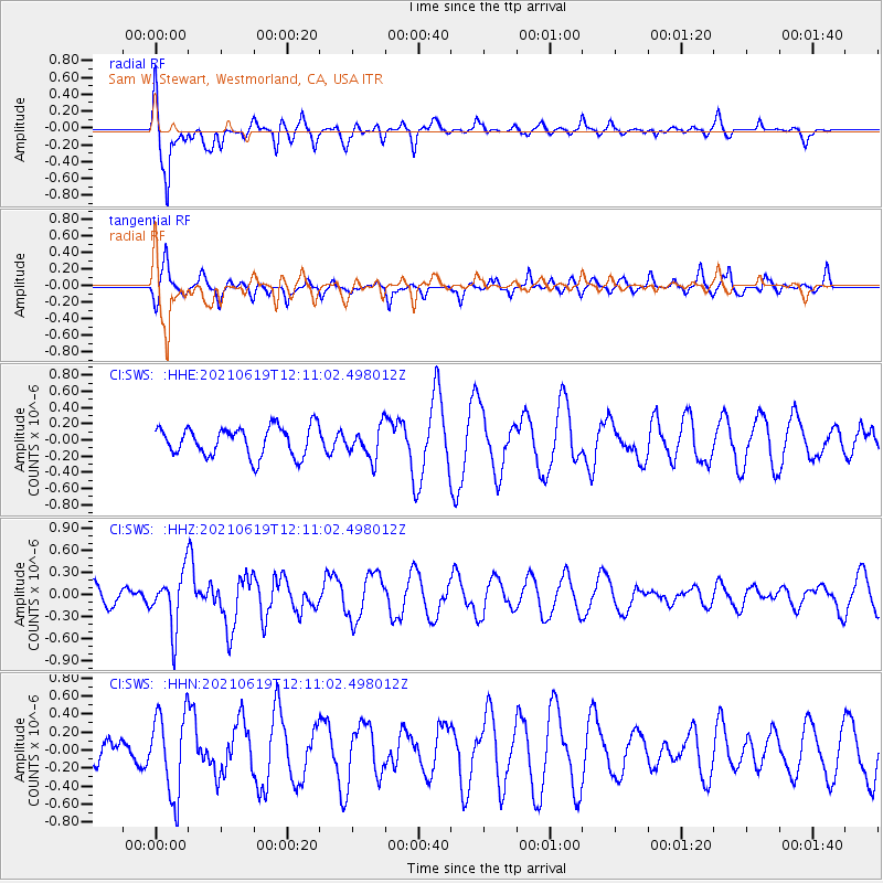
SWS Sam W. Stewart, Westmorland, CA, USA - Earthquake Result Viewer
*The percent match for this event was below the threshold and hence no stack was calculated.
| Earthquake location: |
Fiji Islands Region |
| Earthquake latitude/longitude: |
-16.4/173.1 |
| Earthquake time(UTC): |
2021/06/19 (170) 11:59:05 GMT |
| Earthquake Depth: |
10 km |
| Earthquake Magnitude: |
5.8 mww |
| Earthquake Catalog/Contributor: |
NEIC PDE/us |
|
| Network: |
CI Caltech Regional Seismic Network |
| Station: |
SWS Sam W. Stewart, Westmorland, CA, USA |
| Lat/Lon: |
32.94 N/115.80 W |
| Elevation: |
140 m |
|
| Distance: |
83.7 deg |
| Az: |
53.168 deg |
| Baz: |
246.036 deg |
| Ray Param: |
$rayparam |
*The percent match for this event was below the threshold and hence was not used in the summary stack. |
|
| Radial Match: |
72.19232 % |
| Radial Bump: |
356 |
| Transverse Match: |
76.88526 % |
| Transverse Bump: |
358 |
| SOD ConfigId: |
25131211 |
| Insert Time: |
2021-07-03 12:09:16.385 +0000 |
| GWidth: |
2.5 |
| Max Bumps: |
400 |
| Tol: |
0.001 |
|
Signal To Noise
| Channel | StoN | STA | LTA |
| CI:SWS: :HHZ:20210619T12:11:02.498012Z | 2.614638 | 3.7287472E-7 | 1.4261046E-7 |
| CI:SWS: :HHN:20210619T12:11:02.498012Z | 1.5223035 | 4.5567361E-7 | 2.9933165E-7 |
| CI:SWS: :HHE:20210619T12:11:02.498012Z | 1.0805372 | 1.9454819E-7 | 1.8004765E-7 |
| Arrivals |
| Ps | |
| PpPs | |
| PsPs/PpSs | |


