You are here: Home > Network List > IU - Global Seismograph Network (GSN - IRIS/USGS) Stations List
> Station MAKZ Makanchi, Kazakhstan > Earthquake Result Viewer
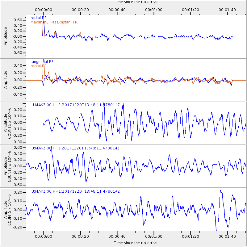
MAKZ Makanchi, Kazakhstan - Earthquake Result Viewer
*The percent match for this event was below the threshold and hence no stack was calculated.
| Earthquake location: |
Southeast Of Shikoku, Japan |
| Earthquake latitude/longitude: |
30.6/132.1 |
| Earthquake time(UTC): |
2017/12/20 (354) 13:40:54 GMT |
| Earthquake Depth: |
10 km |
| Earthquake Magnitude: |
5.5 Mww |
| Earthquake Catalog/Contributor: |
NEIC PDE/us |
|
| Network: |
IU Global Seismograph Network (GSN - IRIS/USGS) |
| Station: |
MAKZ Makanchi, Kazakhstan |
| Lat/Lon: |
46.81 N/81.98 E |
| Elevation: |
600 m |
|
| Distance: |
41.6 deg |
| Az: |
307.418 deg |
| Baz: |
94.648 deg |
| Ray Param: |
$rayparam |
*The percent match for this event was below the threshold and hence was not used in the summary stack. |
|
| Radial Match: |
72.80012 % |
| Radial Bump: |
389 |
| Transverse Match: |
59.32622 % |
| Transverse Bump: |
400 |
| SOD ConfigId: |
2429771 |
| Insert Time: |
2018-01-03 13:42:13.501 +0000 |
| GWidth: |
2.5 |
| Max Bumps: |
400 |
| Tol: |
0.001 |
|
Signal To Noise
| Channel | StoN | STA | LTA |
| IU:MAKZ:00:HHZ:20171220T13:48:11.478014Z | 4.712795 | 3.198048E-7 | 6.785885E-8 |
| IU:MAKZ:00:HH1:20171220T13:48:11.478014Z | 1.0675024 | 5.4901783E-8 | 5.1430128E-8 |
| IU:MAKZ:00:HH2:20171220T13:48:11.478014Z | 2.3364322 | 1.7312851E-7 | 7.4099525E-8 |
| Arrivals |
| Ps | |
| PpPs | |
| PsPs/PpSs | |


