You are here: Home > Network List > US - United States National Seismic Network Stations List
> Station HAWA Hanford, Washington, USA > Earthquake Result Viewer
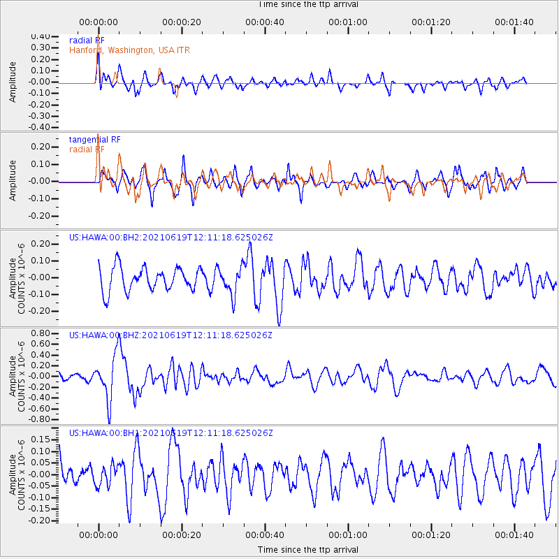
HAWA Hanford, Washington, USA - Earthquake Result Viewer
*The percent match for this event was below the threshold and hence no stack was calculated.
| Earthquake location: |
Fiji Islands Region |
| Earthquake latitude/longitude: |
-16.4/173.1 |
| Earthquake time(UTC): |
2021/06/19 (170) 11:59:05 GMT |
| Earthquake Depth: |
10 km |
| Earthquake Magnitude: |
5.8 mww |
| Earthquake Catalog/Contributor: |
NEIC PDE/us |
|
| Network: |
US United States National Seismic Network |
| Station: |
HAWA Hanford, Washington, USA |
| Lat/Lon: |
46.39 N/119.53 W |
| Elevation: |
364 m |
|
| Distance: |
86.9 deg |
| Az: |
39.771 deg |
| Baz: |
242.539 deg |
| Ray Param: |
$rayparam |
*The percent match for this event was below the threshold and hence was not used in the summary stack. |
|
| Radial Match: |
64.86827 % |
| Radial Bump: |
400 |
| Transverse Match: |
52.416416 % |
| Transverse Bump: |
400 |
| SOD ConfigId: |
25131211 |
| Insert Time: |
2021-07-03 12:17:16.787 +0000 |
| GWidth: |
2.5 |
| Max Bumps: |
400 |
| Tol: |
0.001 |
|
Signal To Noise
| Channel | StoN | STA | LTA |
| US:HAWA:00:BHZ:20210619T12:11:18.625026Z | 5.6289344 | 4.2428388E-7 | 7.537553E-8 |
| US:HAWA:00:BH1:20210619T12:11:18.625026Z | 0.588981 | 4.366153E-8 | 7.4130625E-8 |
| US:HAWA:00:BH2:20210619T12:11:18.625026Z | 1.1735543 | 8.157903E-8 | 6.951449E-8 |
| Arrivals |
| Ps | |
| PpPs | |
| PsPs/PpSs | |


