You are here: Home > Network List > UW - Pacific Northwest Regional Seismic Network Stations List
> Station UMAT Pilot Rock, OR, USA > Earthquake Result Viewer
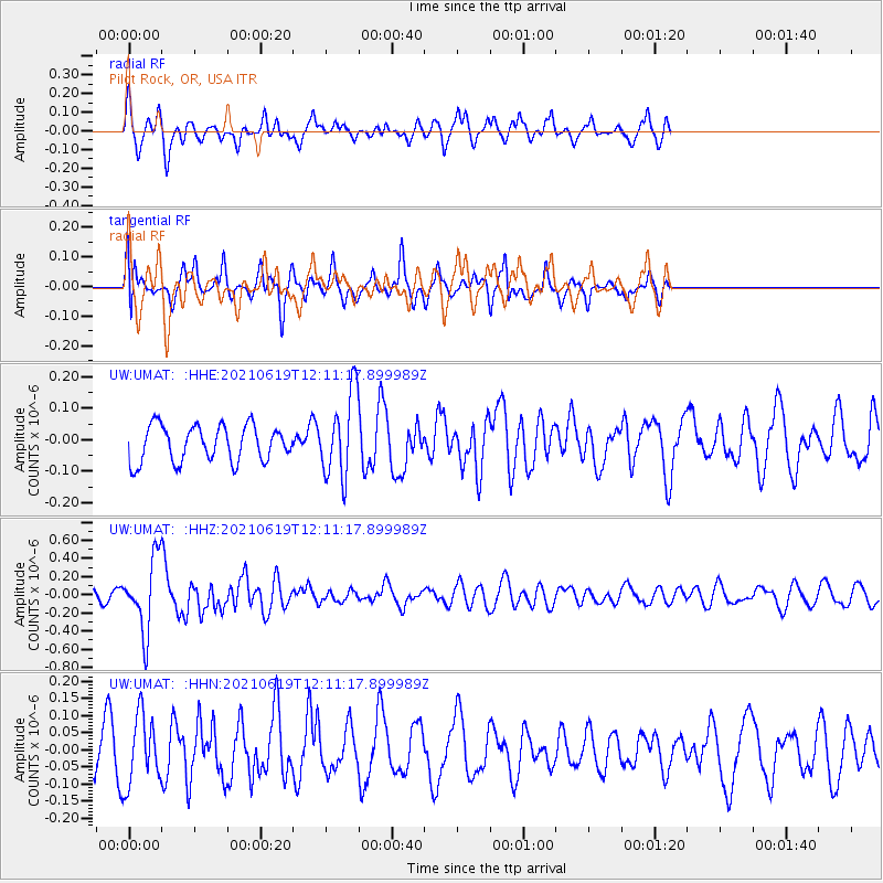
UMAT Pilot Rock, OR, USA - Earthquake Result Viewer
*The percent match for this event was below the threshold and hence no stack was calculated.
| Earthquake location: |
Fiji Islands Region |
| Earthquake latitude/longitude: |
-16.4/173.1 |
| Earthquake time(UTC): |
2021/06/19 (170) 11:59:05 GMT |
| Earthquake Depth: |
10 km |
| Earthquake Magnitude: |
5.8 mww |
| Earthquake Catalog/Contributor: |
NEIC PDE/us |
|
| Network: |
UW Pacific Northwest Regional Seismic Network |
| Station: |
UMAT Pilot Rock, OR, USA |
| Lat/Lon: |
45.29 N/118.96 W |
| Elevation: |
1318 m |
|
| Distance: |
86.8 deg |
| Az: |
40.936 deg |
| Baz: |
243.013 deg |
| Ray Param: |
$rayparam |
*The percent match for this event was below the threshold and hence was not used in the summary stack. |
|
| Radial Match: |
68.07326 % |
| Radial Bump: |
400 |
| Transverse Match: |
56.07369 % |
| Transverse Bump: |
400 |
| SOD ConfigId: |
25131211 |
| Insert Time: |
2021-07-03 12:19:36.564 +0000 |
| GWidth: |
2.5 |
| Max Bumps: |
400 |
| Tol: |
0.001 |
|
Signal To Noise
| Channel | StoN | STA | LTA |
| UW:UMAT: :HHZ:20210619T12:11:17.899989Z | 8.424124 | 3.9045307E-7 | 4.6349403E-8 |
| UW:UMAT: :HHN:20210619T12:11:17.899989Z | 1.44313 | 1.00350015E-7 | 6.953636E-8 |
| UW:UMAT: :HHE:20210619T12:11:17.899989Z | 2.3035684 | 1.3116778E-7 | 5.694113E-8 |
| Arrivals |
| Ps | |
| PpPs | |
| PsPs/PpSs | |


