You are here: Home > Network List > WY - Yellowstone Wyoming Seismic Network Stations List
> Station YEE East Entrance, YNP, WY, USA > Earthquake Result Viewer
YEE East Entrance, YNP, WY, USA - Earthquake Result Viewer
| Earthquake location: |
Fiji Islands Region |
| Earthquake latitude/longitude: |
-16.4/173.1 |
| Earthquake time(UTC): |
2021/06/19 (170) 11:59:05 GMT |
| Earthquake Depth: |
10 km |
| Earthquake Magnitude: |
5.8 mww |
| Earthquake Catalog/Contributor: |
NEIC PDE/us |
|
| Network: |
WY Yellowstone Wyoming Seismic Network |
| Station: |
YEE East Entrance, YNP, WY, USA |
| Lat/Lon: |
44.49 N/109.90 W |
| Elevation: |
2270 m |
|
| Distance: |
92.3 deg |
| Az: |
44.266 deg |
| Baz: |
249.42 deg |
| Ray Param: |
0.04147532 |
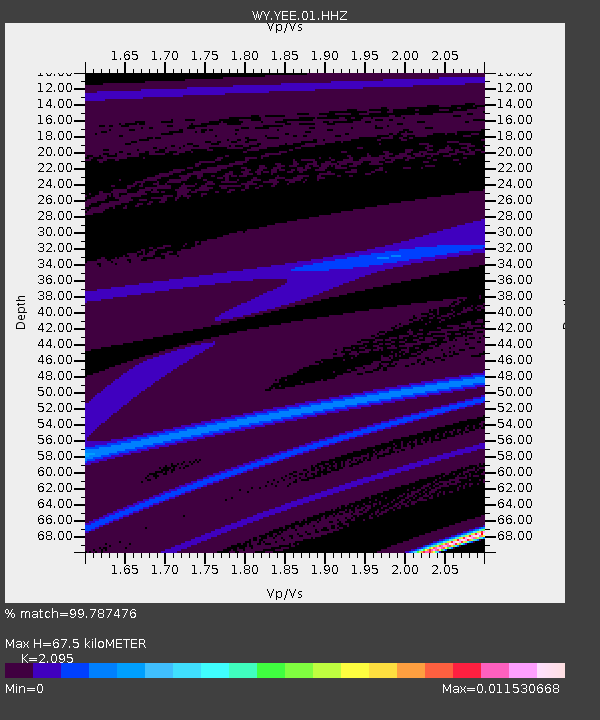
| Estimated Moho Depth: |
67.5 km |
| Estimated Crust Vp/Vs: |
2.10 |
| Assumed Crust Vp: |
6.242 km/s |
| Estimated Crust Vs: |
2.979 km/s |
| Estimated Crust Poisson's Ratio: |
0.35 |
|
| Radial Match: |
99.787476 % |
| Radial Bump: |
19 |
| Transverse Match: |
99.99429 % |
| Transverse Bump: |
2 |
| SOD ConfigId: |
25131211 |
| Insert Time: |
2021-07-03 12:19:51.930 +0000 |
| GWidth: |
2.5 |
| Max Bumps: |
400 |
| Tol: |
0.001 |
|

Signal To Noise
| Channel | StoN | STA | LTA |
| WY:YEE:01:HHZ:20210619T12:11:44.000026Z | 1.7195493 | 1.2823455E-7 | 7.457451E-8 |
| WY:YEE:01:HHN:20210619T12:11:44.000026Z | 1.726655 | 1.5776493E-7 | 9.137027E-8 |
| WY:YEE:01:HHE:20210619T12:11:44.000026Z | 0.84547335 | 3.0737686E-9 | 3.6355596E-9 |
| Arrivals |
| Ps | 12 SECOND |
| PpPs | 33 SECOND |
| PsPs/PpSs | 45 SECOND |


