You are here: Home > Network List > WY - Yellowstone Wyoming Seismic Network Stations List
> Station YHH Holmes Hill, YNP, WY, USA > Earthquake Result Viewer
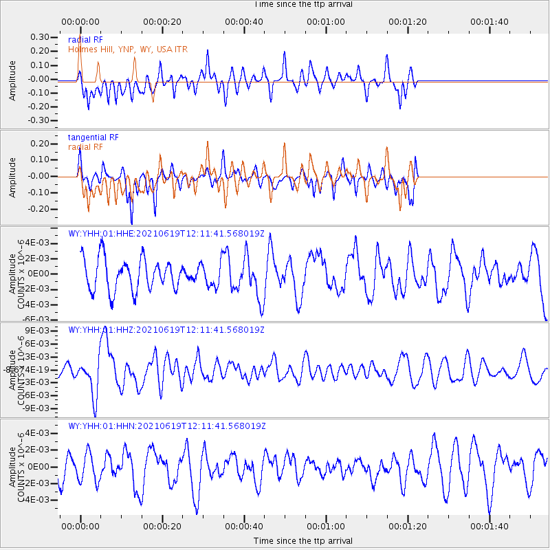
YHH Holmes Hill, YNP, WY, USA - Earthquake Result Viewer
*The percent match for this event was below the threshold and hence no stack was calculated.
| Earthquake location: |
Fiji Islands Region |
| Earthquake latitude/longitude: |
-16.4/173.1 |
| Earthquake time(UTC): |
2021/06/19 (170) 11:59:05 GMT |
| Earthquake Depth: |
10 km |
| Earthquake Magnitude: |
5.8 mww |
| Earthquake Catalog/Contributor: |
NEIC PDE/us |
|
| Network: |
WY Yellowstone Wyoming Seismic Network |
| Station: |
YHH Holmes Hill, YNP, WY, USA |
| Lat/Lon: |
44.79 N/110.85 W |
| Elevation: |
2717 m |
|
| Distance: |
91.8 deg |
| Az: |
43.74 deg |
| Baz: |
248.772 deg |
| Ray Param: |
$rayparam |
*The percent match for this event was below the threshold and hence was not used in the summary stack. |
|
| Radial Match: |
36.70711 % |
| Radial Bump: |
347 |
| Transverse Match: |
60.17266 % |
| Transverse Bump: |
294 |
| SOD ConfigId: |
25131211 |
| Insert Time: |
2021-07-03 12:19:54.714 +0000 |
| GWidth: |
2.5 |
| Max Bumps: |
400 |
| Tol: |
0.001 |
|
Signal To Noise
| Channel | StoN | STA | LTA |
| WY:YHH:01:HHZ:20210619T12:11:41.568019Z | 2.5357893 | 4.4170387E-9 | 1.7418794E-9 |
| WY:YHH:01:HHN:20210619T12:11:41.568019Z | 0.9348742 | 1.7352625E-9 | 1.8561455E-9 |
| WY:YHH:01:HHE:20210619T12:11:41.568019Z | 0.76444274 | 1.5945619E-9 | 2.085914E-9 |
| Arrivals |
| Ps | |
| PpPs | |
| PsPs/PpSs | |


