You are here: Home > Network List > US - United States National Seismic Network Stations List
> Station NEW Newport, Washington, USA > Earthquake Result Viewer
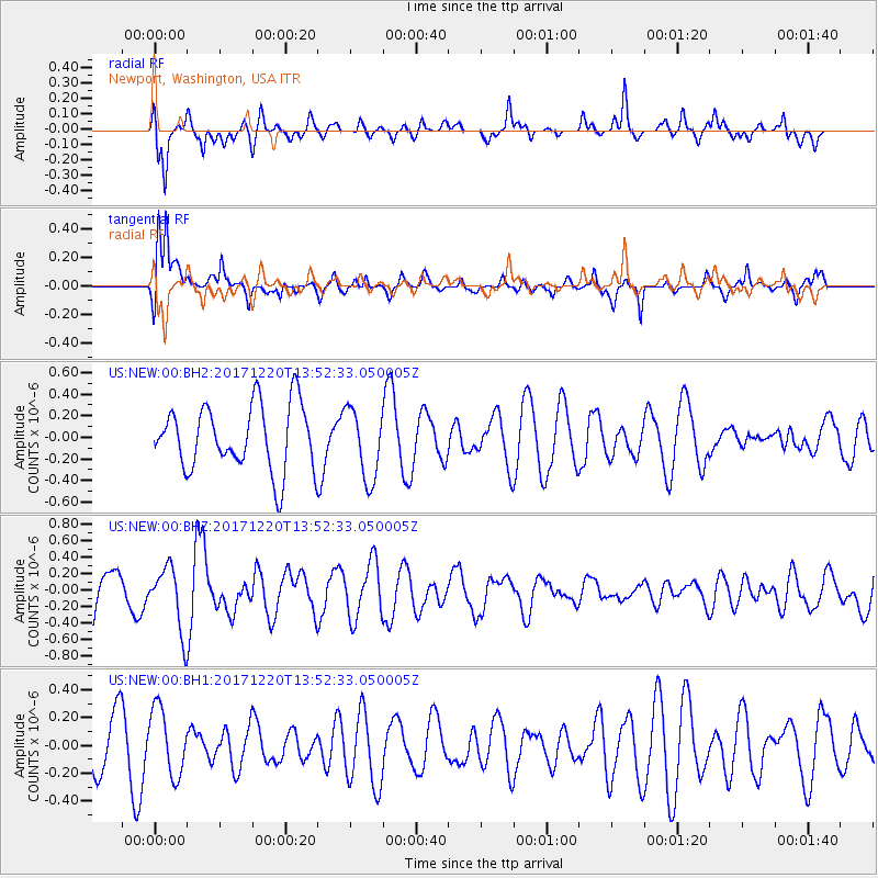
NEW Newport, Washington, USA - Earthquake Result Viewer
*The percent match for this event was below the threshold and hence no stack was calculated.
| Earthquake location: |
Southeast Of Shikoku, Japan |
| Earthquake latitude/longitude: |
30.6/132.1 |
| Earthquake time(UTC): |
2017/12/20 (354) 13:40:54 GMT |
| Earthquake Depth: |
10 km |
| Earthquake Magnitude: |
5.5 Mww |
| Earthquake Catalog/Contributor: |
NEIC PDE/us |
|
| Network: |
US United States National Seismic Network |
| Station: |
NEW Newport, Washington, USA |
| Lat/Lon: |
48.26 N/117.12 W |
| Elevation: |
760 m |
|
| Distance: |
80.1 deg |
| Az: |
39.353 deg |
| Baz: |
305.112 deg |
| Ray Param: |
$rayparam |
*The percent match for this event was below the threshold and hence was not used in the summary stack. |
|
| Radial Match: |
64.238716 % |
| Radial Bump: |
400 |
| Transverse Match: |
75.32727 % |
| Transverse Bump: |
400 |
| SOD ConfigId: |
2429771 |
| Insert Time: |
2018-01-03 13:43:30.290 +0000 |
| GWidth: |
2.5 |
| Max Bumps: |
400 |
| Tol: |
0.001 |
|
Signal To Noise
| Channel | StoN | STA | LTA |
| US:NEW:00:BHZ:20171220T13:52:33.050005Z | 1.6341051 | 3.8121675E-7 | 2.3328778E-7 |
| US:NEW:00:BH1:20171220T13:52:33.050005Z | 1.0433558 | 2.4002478E-7 | 2.3005074E-7 |
| US:NEW:00:BH2:20171220T13:52:33.050005Z | 1.0864432 | 3.2869468E-7 | 3.02542E-7 |
| Arrivals |
| Ps | |
| PpPs | |
| PsPs/PpSs | |


