You are here: Home > Network List > KZ - Kazakhstan Network Stations List
> Station KUR Kurchatov, Kazakstan > Earthquake Result Viewer
KUR Kurchatov, Kazakstan - Earthquake Result Viewer
| Earthquake location: |
Kuril Islands |
| Earthquake latitude/longitude: |
43.6/147.1 |
| Earthquake time(UTC): |
1994/10/18 (291) 17:12:51 GMT |
| Earthquake Depth: |
66 km |
| Earthquake Magnitude: |
6.1 MB, 6.1 UNKNOWN, 5.9 MW |
| Earthquake Catalog/Contributor: |
WHDF/NEIC |
|
| Network: |
KZ Kazakhstan Network |
| Station: |
KUR Kurchatov, Kazakstan |
| Lat/Lon: |
50.71 N/78.62 E |
| Elevation: |
240 m |
|
| Distance: |
45.6 deg |
| Az: |
304.152 deg |
| Baz: |
71.159 deg |
| Ray Param: |
0.07095698 |
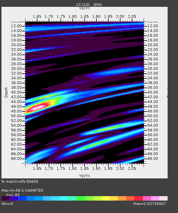
| Estimated Moho Depth: |
46.5 km |
| Estimated Crust Vp/Vs: |
1.65 |
| Assumed Crust Vp: |
6.552 km/s |
| Estimated Crust Vs: |
3.971 km/s |
| Estimated Crust Poisson's Ratio: |
0.21 |
|
| Radial Match: |
95.95685 % |
| Radial Bump: |
299 |
| Transverse Match: |
87.38094 % |
| Transverse Bump: |
400 |
| SOD ConfigId: |
17000 |
| Insert Time: |
2010-03-09 09:25:37.891 +0000 |
| GWidth: |
2.5 |
| Max Bumps: |
400 |
| Tol: |
0.001 |
|

Signal To Noise
| Channel | StoN | STA | LTA |
| KZ:KUR: :BHN:19941018T17:20:34.721991Z | 14.335052 | 6.160536E-7 | 4.2975337E-8 |
| KZ:KUR: :BHE:19941018T17:20:34.721991Z | 48.532055 | 2.967262E-6 | 6.114025E-8 |
| KZ:KUR: :BHZ:19941018T17:20:34.721991Z | 89.19244 | 5.993289E-6 | 6.719503E-8 |
| Arrivals |
| Ps | 5.0 SECOND |
| PpPs | 18 SECOND |
| PsPs/PpSs | 22 SECOND |


