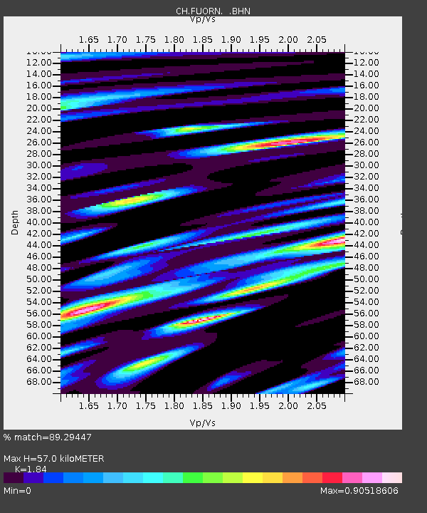
FUORN CH.FUORN - Earthquake Result Viewer

Earthquake location: Central Mid-Atlantic Ridge
Earthquake latitude/longitude: 7.3/-34.9
Earthquake time(UTC): 2008/05/23 (144) 19:35:34 GMT
Earthquake Depth: 9.0 km
Earthquake Magnitude: 6.0 MB, 6.4 MS, 6.5 MW, 6.5 MW
Earthquake Catalog/Contributor: WHDF/NEIC
Network: CH Switzerland Seismological Network
Station: FUORN CH.FUORN
Lat/Lon: 46.62 N/10.26 E
Elevation: 2333 m
Distance: 55.0 deg
Az: 36.636 deg
Baz: 239.182 deg
Ray Param: 0.0650937
Estimated Moho Depth: 57.0 km
Estimated Crust Vp/Vs: 1.84
Assumed Crust Vp: 6.35 km/s
Estimated Crust Vs: 3.451 km/s
Estimated Crust Poisson's Ratio: 0.29
Radial Match: 89.29447 %
Radial Bump: 400
Transverse Match: 78.48069 %
Transverse Bump: 400
SOD ConfigId: 2504
Insert Time: 2010-02-25 19:17:29.643 +0000
GWidth: 2.5
Max Bumps: 400
Tol: 0.001

Signal To Noise

ChannelStoNSTALTA
CH:FUORN: :BHN:20080523T19:44:35.400022Z20.1862539.960847E-74.9344703E-8
CH:FUORN: :BHE:20080523T19:44:35.400022Z6.6218463.2142864E-74.854064E-8
CH:FUORN: :BHZ:20080523T19:44:35.400022Z7.48139674.068038E-75.4375384E-8
Arrivals
Ps7.9 SECOND
PpPs24 SECOND
PsPs/PpSs32 SECOND