You are here: Home > Network List > KZ - Kazakhstan Network Stations List
> Station KUR Kurchatov, Kazakstan > Earthquake Result Viewer
KUR Kurchatov, Kazakstan - Earthquake Result Viewer
| Earthquake location: |
Myanmar |
| Earthquake latitude/longitude: |
17.9/96.4 |
| Earthquake time(UTC): |
1994/08/19 (231) 21:02:45 GMT |
| Earthquake Depth: |
12 km |
| Earthquake Magnitude: |
5.5 MB, 5.6 MS, 6.0 UNKNOWN, 5.8 MW |
| Earthquake Catalog/Contributor: |
WHDF/NEIC |
|
| Network: |
KZ Kazakhstan Network |
| Station: |
KUR Kurchatov, Kazakstan |
| Lat/Lon: |
50.71 N/78.62 E |
| Elevation: |
240 m |
|
| Distance: |
35.7 deg |
| Az: |
340.605 deg |
| Baz: |
150.166 deg |
| Ray Param: |
0.07707549 |
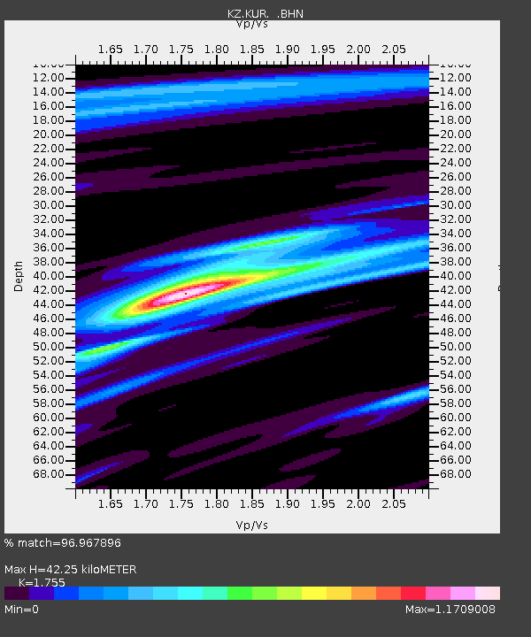
| Estimated Moho Depth: |
42.25 km |
| Estimated Crust Vp/Vs: |
1.75 |
| Assumed Crust Vp: |
6.552 km/s |
| Estimated Crust Vs: |
3.734 km/s |
| Estimated Crust Poisson's Ratio: |
0.26 |
|
| Radial Match: |
96.967896 % |
| Radial Bump: |
384 |
| Transverse Match: |
84.713524 % |
| Transverse Bump: |
400 |
| SOD ConfigId: |
16938 |
| Insert Time: |
2010-03-09 09:25:53.107 +0000 |
| GWidth: |
2.5 |
| Max Bumps: |
400 |
| Tol: |
0.001 |
|

Signal To Noise
| Channel | StoN | STA | LTA |
| KZ:KUR: :BHN:19940819T21:09:12.437012Z | 7.063523 | 2.6145034E-7 | 3.7014157E-8 |
| KZ:KUR: :BHE:19940819T21:09:12.437012Z | 5.6559277 | 1.6870487E-7 | 2.9827977E-8 |
| KZ:KUR: :BHZ:19940819T21:09:12.437012Z | 9.983992 | 6.086186E-7 | 6.0959444E-8 |
| Arrivals |
| Ps | 5.3 SECOND |
| PpPs | 16 SECOND |
| PsPs/PpSs | 22 SECOND |


