You are here: Home > Network List > AK - Alaska Regional Network Stations List
> Station M26K Nabesna, AK, USA > Earthquake Result Viewer
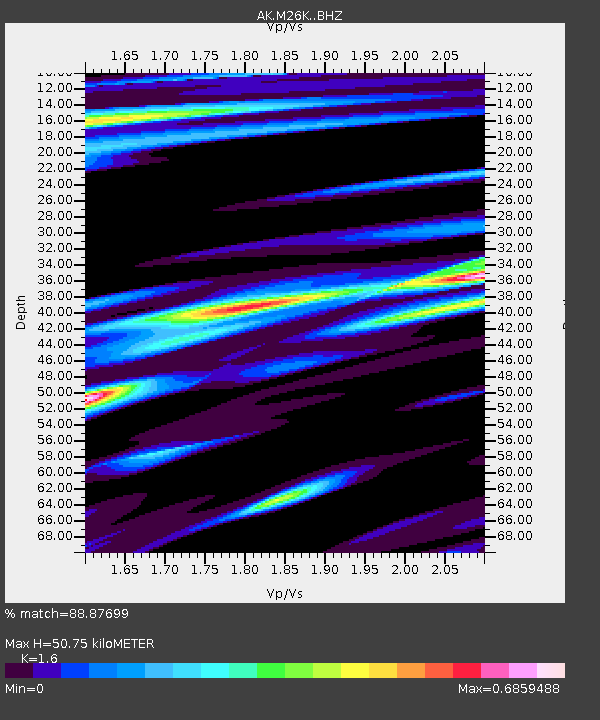
M26K Nabesna, AK, USA - Earthquake Result Viewer
| Earthquake location: |
Kermadec Islands, New Zealand |
| Earthquake latitude/longitude: |
-30.2/-177.8 |
| Earthquake time(UTC): |
2021/06/20 (171) 17:05:48 GMT |
| Earthquake Depth: |
10 km |
| Earthquake Magnitude: |
6.5 mww |
| Earthquake Catalog/Contributor: |
NEIC PDE/us |
|
| Network: |
AK Alaska Regional Network |
| Station: |
M26K Nabesna, AK, USA |
| Lat/Lon: |
62.40 N/143.00 W |
| Elevation: |
888 m |
|
| Distance: |
96.4 deg |
| Az: |
15.52 deg |
| Baz: |
209.825 deg |
| Ray Param: |
0.040517293 |
| Estimated Moho Depth: |
50.75 km |
| Estimated Crust Vp/Vs: |
1.60 |
| Assumed Crust Vp: |
6.566 km/s |
| Estimated Crust Vs: |
4.104 km/s |
| Estimated Crust Poisson's Ratio: |
0.18 |
|
| Radial Match: |
88.87699 % |
| Radial Bump: |
400 |
| Transverse Match: |
73.45203 % |
| Transverse Bump: |
400 |
| SOD ConfigId: |
25131211 |
| Insert Time: |
2021-07-04 17:08:21.425 +0000 |
| GWidth: |
2.5 |
| Max Bumps: |
400 |
| Tol: |
0.001 |
|

Signal To Noise
| Channel | StoN | STA | LTA |
| AK:M26K: :BHZ:20210620T17:18:45.599994Z | 15.99602 | 8.46502E-7 | 5.291954E-8 |
| AK:M26K: :BHN:20210620T17:18:45.599994Z | 3.848042 | 2.3098288E-7 | 6.002608E-8 |
| AK:M26K: :BHE:20210620T17:18:45.599994Z | 1.5497836 | 1.2948222E-7 | 8.354857E-8 |
| Arrivals |
| Ps | 4.7 SECOND |
| PpPs | 20 SECOND |
| PsPs/PpSs | 24 SECOND |


