You are here: Home > Network List > KZ - Kazakhstan Network Stations List
> Station KUR Kurchatov, Kazakstan > Earthquake Result Viewer
KUR Kurchatov, Kazakstan - Earthquake Result Viewer
| Earthquake location: |
Lake Tanganyika Region |
| Earthquake latitude/longitude: |
-7.3/31.8 |
| Earthquake time(UTC): |
1994/08/18 (230) 00:45:48 GMT |
| Earthquake Depth: |
29 km |
| Earthquake Magnitude: |
6.0 MB, 5.8 MS, 6.1 UNKNOWN, 5.9 MW |
| Earthquake Catalog/Contributor: |
WHDF/NEIC |
|
| Network: |
KZ Kazakhstan Network |
| Station: |
KUR Kurchatov, Kazakstan |
| Lat/Lon: |
50.71 N/78.62 E |
| Elevation: |
240 m |
|
| Distance: |
70.5 deg |
| Az: |
29.458 deg |
| Baz: |
230.115 deg |
| Ray Param: |
0.05488678 |
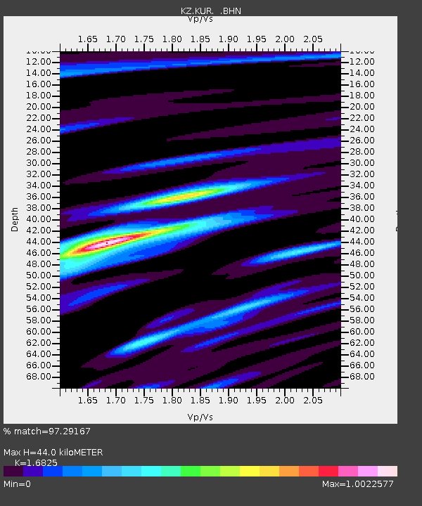
| Estimated Moho Depth: |
44.0 km |
| Estimated Crust Vp/Vs: |
1.68 |
| Assumed Crust Vp: |
6.552 km/s |
| Estimated Crust Vs: |
3.894 km/s |
| Estimated Crust Poisson's Ratio: |
0.23 |
|
| Radial Match: |
97.29167 % |
| Radial Bump: |
400 |
| Transverse Match: |
91.915665 % |
| Transverse Bump: |
400 |
| SOD ConfigId: |
17000 |
| Insert Time: |
2010-03-09 09:26:00.916 +0000 |
| GWidth: |
2.5 |
| Max Bumps: |
400 |
| Tol: |
0.001 |
|

Signal To Noise
| Channel | StoN | STA | LTA |
| KZ:KUR: :BHN:19940818T00:56:29.013Z | 10.944364 | 2.2103288E-7 | 2.0196048E-8 |
| KZ:KUR: :BHE:19940818T00:56:29.013Z | 12.008512 | 2.5052788E-7 | 2.0862524E-8 |
| KZ:KUR: :BHZ:19940818T00:56:29.013Z | 21.894602 | 9.642317E-7 | 4.40397E-8 |
| Arrivals |
| Ps | 4.8 SECOND |
| PpPs | 17 SECOND |
| PsPs/PpSs | 22 SECOND |


