You are here: Home > Network List > AT - Alaska Tsunami Warning Seismic System Stations List
> Station AKUT Akutan, Alaska > Earthquake Result Viewer
AKUT Akutan, Alaska - Earthquake Result Viewer
| Earthquake location: |
Kermadec Islands, New Zealand |
| Earthquake latitude/longitude: |
-30.2/-177.8 |
| Earthquake time(UTC): |
2021/06/20 (171) 17:05:48 GMT |
| Earthquake Depth: |
10 km |
| Earthquake Magnitude: |
6.5 mww |
| Earthquake Catalog/Contributor: |
NEIC PDE/us |
|
| Network: |
AT Alaska Tsunami Warning Seismic System |
| Station: |
AKUT Akutan, Alaska |
| Lat/Lon: |
54.14 N/165.77 W |
| Elevation: |
19 m |
|
| Distance: |
84.6 deg |
| Az: |
7.082 deg |
| Baz: |
190.449 deg |
| Ray Param: |
0.04534254 |
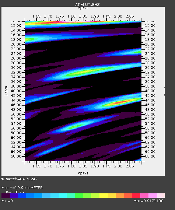
| Estimated Moho Depth: |
10.0 km |
| Estimated Crust Vp/Vs: |
1.82 |
| Assumed Crust Vp: |
5.989 km/s |
| Estimated Crust Vs: |
3.295 km/s |
| Estimated Crust Poisson's Ratio: |
0.28 |
|
| Radial Match: |
84.70247 % |
| Radial Bump: |
400 |
| Transverse Match: |
83.26933 % |
| Transverse Bump: |
371 |
| SOD ConfigId: |
25131211 |
| Insert Time: |
2021-07-04 17:09:57.767 +0000 |
| GWidth: |
2.5 |
| Max Bumps: |
400 |
| Tol: |
0.001 |
|

Signal To Noise
| Channel | StoN | STA | LTA |
| AT:AKUT: :BHZ:20210620T17:17:50.320026Z | 15.229713 | 4.432753E-6 | 2.910595E-7 |
| AT:AKUT: :BHN:20210620T17:17:50.320026Z | 4.946916 | 1.3126844E-6 | 2.6535406E-7 |
| AT:AKUT: :BHE:20210620T17:17:50.320026Z | 3.283495 | 8.7681457E-7 | 2.67037E-7 |
| Arrivals |
| Ps | 1.4 SECOND |
| PpPs | 4.6 SECOND |
| PsPs/PpSs | 6.0 SECOND |


