You are here: Home > Network List > AV - Alaska Volcano Observatory Stations List
> Station AKHS Akutan Broiad Bright, Akutan Volcano, Alaska > Earthquake Result Viewer
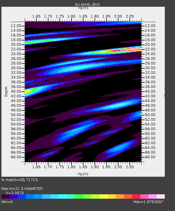
AKHS Akutan Broiad Bright, Akutan Volcano, Alaska - Earthquake Result Viewer
| Earthquake location: |
Kermadec Islands, New Zealand |
| Earthquake latitude/longitude: |
-30.2/-177.8 |
| Earthquake time(UTC): |
2021/06/20 (171) 17:05:48 GMT |
| Earthquake Depth: |
10 km |
| Earthquake Magnitude: |
6.5 mww |
| Earthquake Catalog/Contributor: |
NEIC PDE/us |
|
| Network: |
AV Alaska Volcano Observatory |
| Station: |
AKHS Akutan Broiad Bright, Akutan Volcano, Alaska |
| Lat/Lon: |
54.15 N/165.89 W |
| Elevation: |
150 m |
|
| Distance: |
84.6 deg |
| Az: |
7.012 deg |
| Baz: |
190.349 deg |
| Ray Param: |
0.045338493 |
| Estimated Moho Depth: |
21.5 km |
| Estimated Crust Vp/Vs: |
2.09 |
| Assumed Crust Vp: |
5.989 km/s |
| Estimated Crust Vs: |
2.869 km/s |
| Estimated Crust Poisson's Ratio: |
0.35 |
|
| Radial Match: |
85.71715 % |
| Radial Bump: |
400 |
| Transverse Match: |
86.26923 % |
| Transverse Bump: |
400 |
| SOD ConfigId: |
25131211 |
| Insert Time: |
2021-07-04 17:10:58.536 +0000 |
| GWidth: |
2.5 |
| Max Bumps: |
400 |
| Tol: |
0.001 |
|

Signal To Noise
| Channel | StoN | STA | LTA |
| AV:AKHS: :BHZ:20210620T17:17:50.359027Z | 28.4794 | 2.3758705E-6 | 8.3424176E-8 |
| AV:AKHS: :BHN:20210620T17:17:50.359027Z | 14.159559 | 2.404555E-6 | 1.698185E-7 |
| AV:AKHS: :BHE:20210620T17:17:50.359027Z | 14.310453 | 1.4704926E-6 | 1.0275653E-7 |
| Arrivals |
| Ps | 4.0 SECOND |
| PpPs | 11 SECOND |
| PsPs/PpSs | 15 SECOND |


