You are here: Home > Network List > IU - Global Seismograph Network (GSN - IRIS/USGS) Stations List
> Station CTAO Charters Towers, Australia > Earthquake Result Viewer
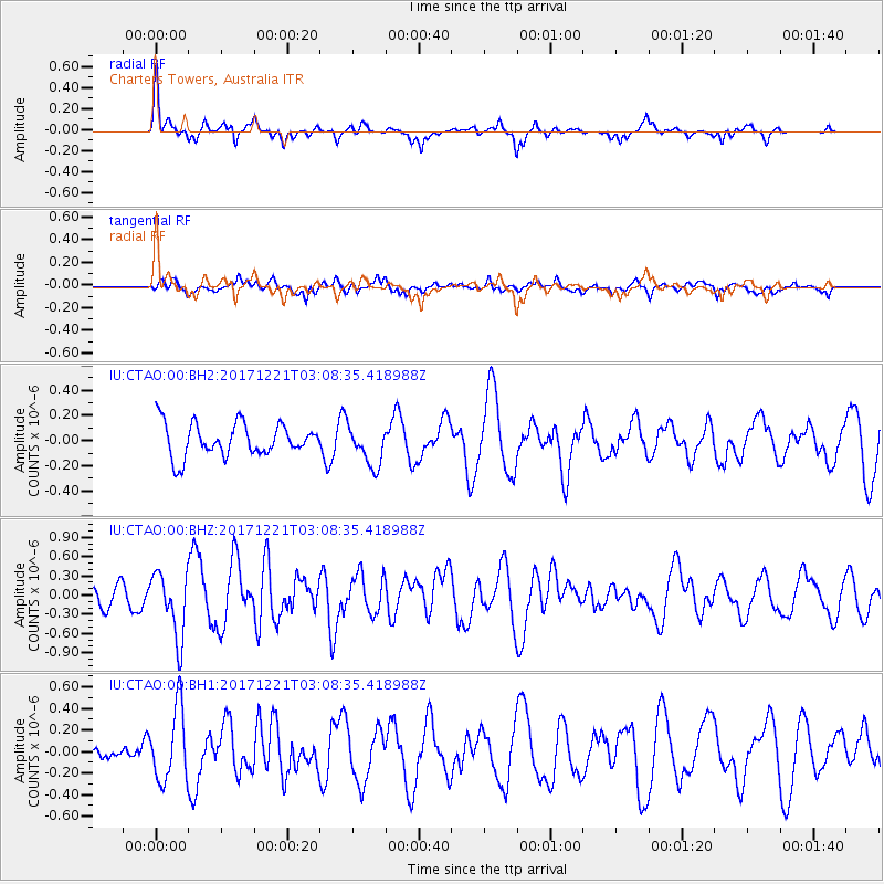
CTAO Charters Towers, Australia - Earthquake Result Viewer
*The percent match for this event was below the threshold and hence no stack was calculated.
| Earthquake location: |
Southeast Of Honshu, Japan |
| Earthquake latitude/longitude: |
29.3/142.7 |
| Earthquake time(UTC): |
2017/12/21 (355) 03:00:19 GMT |
| Earthquake Depth: |
16 km |
| Earthquake Magnitude: |
5.7 Mww |
| Earthquake Catalog/Contributor: |
NEIC PDE/us |
|
| Network: |
IU Global Seismograph Network (GSN - IRIS/USGS) |
| Station: |
CTAO Charters Towers, Australia |
| Lat/Lon: |
20.09 S/146.25 E |
| Elevation: |
357 m |
|
| Distance: |
49.2 deg |
| Az: |
175.611 deg |
| Baz: |
355.921 deg |
| Ray Param: |
$rayparam |
*The percent match for this event was below the threshold and hence was not used in the summary stack. |
|
| Radial Match: |
67.58029 % |
| Radial Bump: |
380 |
| Transverse Match: |
46.181824 % |
| Transverse Bump: |
391 |
| SOD ConfigId: |
2429771 |
| Insert Time: |
2018-01-04 03:01:54.248 +0000 |
| GWidth: |
2.5 |
| Max Bumps: |
400 |
| Tol: |
0.001 |
|
Signal To Noise
| Channel | StoN | STA | LTA |
| IU:CTAO:00:BHZ:20171221T03:08:35.418988Z | 2.5818827 | 5.068205E-7 | 1.9629881E-7 |
| IU:CTAO:00:BH1:20171221T03:08:35.418988Z | 2.4189093 | 3.35248E-7 | 1.3859469E-7 |
| IU:CTAO:00:BH2:20171221T03:08:35.418988Z | 1.2477937 | 1.6148877E-7 | 1.2941946E-7 |
| Arrivals |
| Ps | |
| PpPs | |
| PsPs/PpSs | |


