You are here: Home > Network List > AV - Alaska Volcano Observatory Stations List
> Station MNAT Nateekin Bay, Makushin Volcano, Alaska > Earthquake Result Viewer
MNAT Nateekin Bay, Makushin Volcano, Alaska - Earthquake Result Viewer
| Earthquake location: |
Kermadec Islands, New Zealand |
| Earthquake latitude/longitude: |
-30.2/-177.8 |
| Earthquake time(UTC): |
2021/06/20 (171) 17:05:48 GMT |
| Earthquake Depth: |
10 km |
| Earthquake Magnitude: |
6.5 mww |
| Earthquake Catalog/Contributor: |
NEIC PDE/us |
|
| Network: |
AV Alaska Volcano Observatory |
| Station: |
MNAT Nateekin Bay, Makushin Volcano, Alaska |
| Lat/Lon: |
53.88 N/166.69 W |
| Elevation: |
390 m |
|
| Distance: |
84.3 deg |
| Az: |
6.593 deg |
| Baz: |
189.664 deg |
| Ray Param: |
0.045583334 |
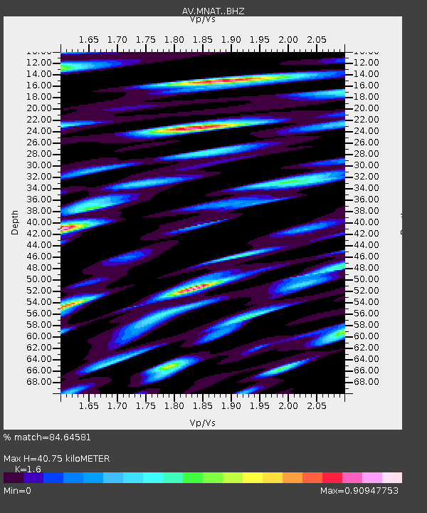
| Estimated Moho Depth: |
40.75 km |
| Estimated Crust Vp/Vs: |
1.60 |
| Assumed Crust Vp: |
3.943 km/s |
| Estimated Crust Vs: |
2.465 km/s |
| Estimated Crust Poisson's Ratio: |
0.18 |
|
| Radial Match: |
84.64581 % |
| Radial Bump: |
400 |
| Transverse Match: |
82.05523 % |
| Transverse Bump: |
400 |
| SOD ConfigId: |
25131211 |
| Insert Time: |
2021-07-04 17:12:42.382 +0000 |
| GWidth: |
2.5 |
| Max Bumps: |
400 |
| Tol: |
0.001 |
|
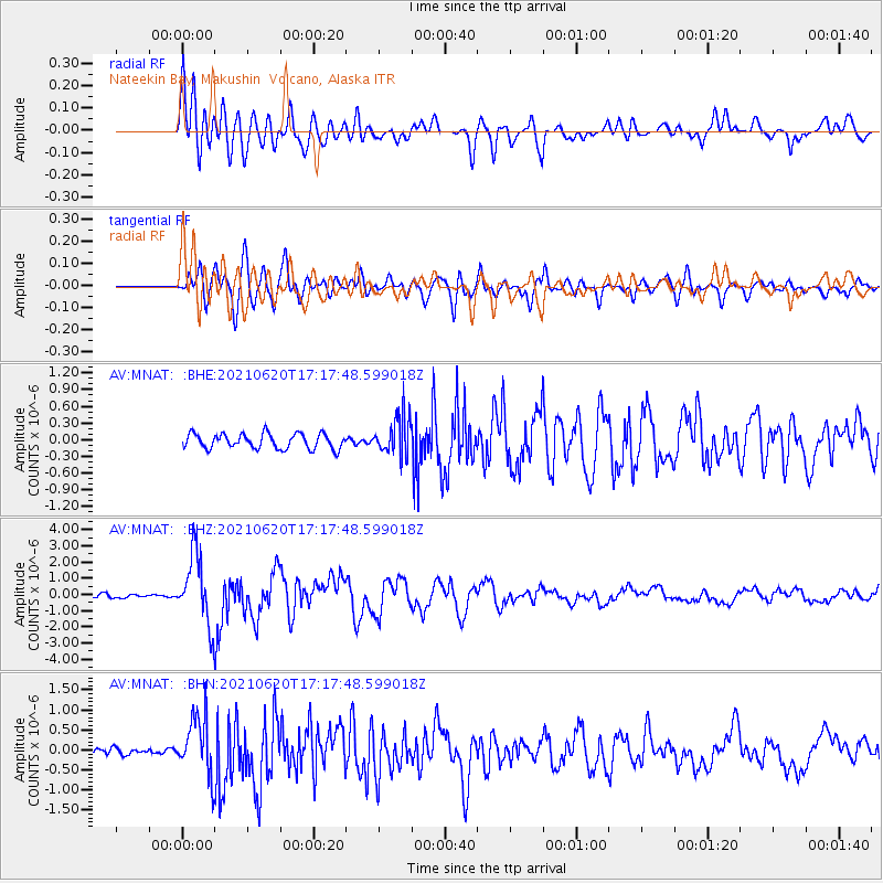
Signal To Noise
| Channel | StoN | STA | LTA |
| AV:MNAT: :BHZ:20210620T17:17:48.599018Z | 19.162294 | 2.1556086E-6 | 1.1249221E-7 |
| AV:MNAT: :BHN:20210620T17:17:48.599018Z | 8.475519 | 7.4324305E-7 | 8.769292E-8 |
| AV:MNAT: :BHE:20210620T17:17:48.599018Z | 2.6026 | 3.5033563E-7 | 1.3460985E-7 |
| Arrivals |
| Ps | 6.3 SECOND |
| PpPs | 27 SECOND |
| PsPs/PpSs | 33 SECOND |


