You are here: Home > Network List > AV - Alaska Volcano Observatory Stations List
> Station S12K Black Hills, AK, USA > Earthquake Result Viewer
S12K Black Hills, AK, USA - Earthquake Result Viewer
| Earthquake location: |
Kermadec Islands, New Zealand |
| Earthquake latitude/longitude: |
-30.2/-177.8 |
| Earthquake time(UTC): |
2021/06/20 (171) 17:05:48 GMT |
| Earthquake Depth: |
10 km |
| Earthquake Magnitude: |
6.5 mww |
| Earthquake Catalog/Contributor: |
NEIC PDE/us |
|
| Network: |
AV Alaska Volcano Observatory |
| Station: |
S12K Black Hills, AK, USA |
| Lat/Lon: |
55.70 N/162.06 W |
| Elevation: |
411 m |
|
| Distance: |
86.6 deg |
| Az: |
8.855 deg |
| Baz: |
193.615 deg |
| Ray Param: |
0.04391939 |
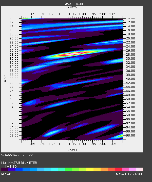
| Estimated Moho Depth: |
27.5 km |
| Estimated Crust Vp/Vs: |
1.85 |
| Assumed Crust Vp: |
5.989 km/s |
| Estimated Crust Vs: |
3.237 km/s |
| Estimated Crust Poisson's Ratio: |
0.29 |
|
| Radial Match: |
93.75622 % |
| Radial Bump: |
400 |
| Transverse Match: |
88.5941 % |
| Transverse Bump: |
400 |
| SOD ConfigId: |
25131211 |
| Insert Time: |
2021-07-04 17:13:13.398 +0000 |
| GWidth: |
2.5 |
| Max Bumps: |
400 |
| Tol: |
0.001 |
|

Signal To Noise
| Channel | StoN | STA | LTA |
| AV:S12K: :BHZ:20210620T17:18:00.149982Z | 23.811152 | 5.242676E-6 | 2.2017734E-7 |
| AV:S12K: :BHN:20210620T17:18:00.149982Z | 10.024369 | 1.60316E-6 | 1.5992627E-7 |
| AV:S12K: :BHE:20210620T17:18:00.149982Z | 7.041795 | 8.686297E-7 | 1.2335346E-7 |
| Arrivals |
| Ps | 4.0 SECOND |
| PpPs | 13 SECOND |
| PsPs/PpSs | 17 SECOND |


