You are here: Home > Network List > KZ - Kazakhstan Network Stations List
> Station KUR Kurchatov, Kazakstan > Earthquake Result Viewer
KUR Kurchatov, Kazakstan - Earthquake Result Viewer
| Earthquake location: |
Kyushu, Japan |
| Earthquake latitude/longitude: |
31.8/131.3 |
| Earthquake time(UTC): |
1996/12/02 (337) 22:17:59 GMT |
| Earthquake Depth: |
49 km |
| Earthquake Magnitude: |
6.0 MB, 6.6 MS, 6.8 UNKNOWN, 6.3 ME |
| Earthquake Catalog/Contributor: |
WHDF/NEIC |
|
| Network: |
KZ Kazakhstan Network |
| Station: |
KUR Kurchatov, Kazakstan |
| Lat/Lon: |
50.71 N/78.62 E |
| Elevation: |
240 m |
|
| Distance: |
42.9 deg |
| Az: |
312.003 deg |
| Baz: |
95.493 deg |
| Ray Param: |
0.07277751 |
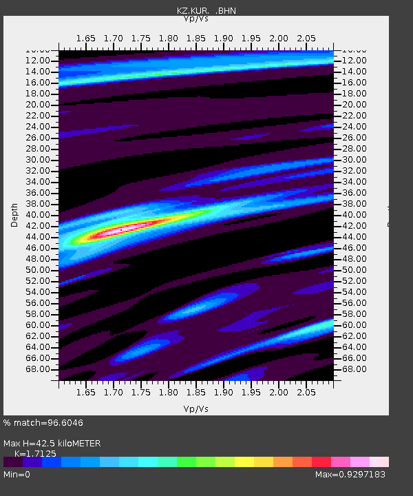
| Estimated Moho Depth: |
42.5 km |
| Estimated Crust Vp/Vs: |
1.71 |
| Assumed Crust Vp: |
6.552 km/s |
| Estimated Crust Vs: |
3.826 km/s |
| Estimated Crust Poisson's Ratio: |
0.24 |
|
| Radial Match: |
96.6046 % |
| Radial Bump: |
259 |
| Transverse Match: |
83.13273 % |
| Transverse Bump: |
400 |
| SOD ConfigId: |
6273 |
| Insert Time: |
2010-03-09 09:26:47.125 +0000 |
| GWidth: |
2.5 |
| Max Bumps: |
400 |
| Tol: |
0.001 |
|

Signal To Noise
| Channel | StoN | STA | LTA |
| KZ:KUR: :BHN:19961202T22:25:22.348987Z | 1.9951227 | 3.14879E-8 | 1.5782437E-8 |
| KZ:KUR: :BHE:19961202T22:25:22.348987Z | 12.218371 | 1.2941881E-7 | 1.05921485E-8 |
| KZ:KUR: :BHZ:19961202T22:25:22.348987Z | 14.306535 | 2.1359787E-7 | 1.4930093E-8 |
| Arrivals |
| Ps | 5.0 SECOND |
| PpPs | 16 SECOND |
| PsPs/PpSs | 21 SECOND |


