You are here: Home > Network List > BC - Red Sismica del Noroeste de Mexico Stations List
> Station CBX CERRO BOLA MEX, , , MEXICO > Earthquake Result Viewer
CBX CERRO BOLA MEX, , , MEXICO - Earthquake Result Viewer
| Earthquake location: |
Kermadec Islands, New Zealand |
| Earthquake latitude/longitude: |
-30.2/-177.8 |
| Earthquake time(UTC): |
2021/06/20 (171) 17:05:48 GMT |
| Earthquake Depth: |
10 km |
| Earthquake Magnitude: |
6.5 mww |
| Earthquake Catalog/Contributor: |
NEIC PDE/us |
|
| Network: |
BC Red Sismica del Noroeste de Mexico |
| Station: |
CBX CERRO BOLA MEX, , , MEXICO |
| Lat/Lon: |
32.31 N/116.66 W |
| Elevation: |
1250 m |
|
| Distance: |
85.0 deg |
| Az: |
48.116 deg |
| Baz: |
229.561 deg |
| Ray Param: |
0.045092445 |
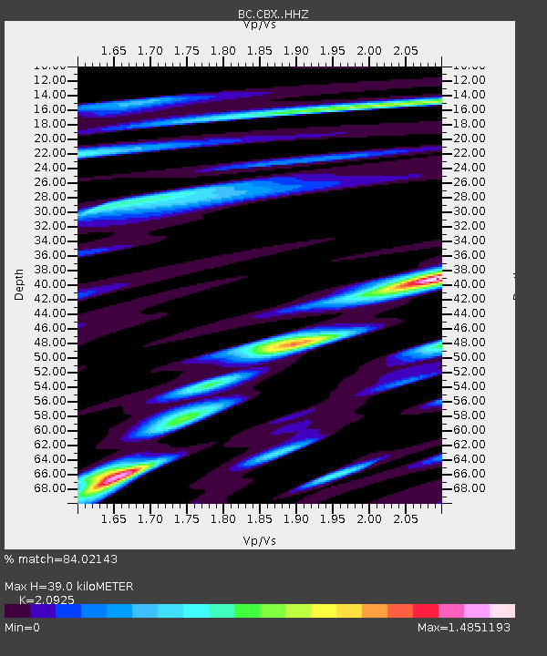
| Estimated Moho Depth: |
39.0 km |
| Estimated Crust Vp/Vs: |
2.09 |
| Assumed Crust Vp: |
6.264 km/s |
| Estimated Crust Vs: |
2.993 km/s |
| Estimated Crust Poisson's Ratio: |
0.35 |
|
| Radial Match: |
84.02143 % |
| Radial Bump: |
400 |
| Transverse Match: |
80.25638 % |
| Transverse Bump: |
400 |
| SOD ConfigId: |
25131211 |
| Insert Time: |
2021-07-04 17:14:06.564 +0000 |
| GWidth: |
2.5 |
| Max Bumps: |
400 |
| Tol: |
0.001 |
|

Signal To Noise
| Channel | StoN | STA | LTA |
| BC:CBX: :HHZ:20210620T17:17:52.070026Z | 10.711628 | 1.9482197E-6 | 1.8187897E-7 |
| BC:CBX: :HHN:20210620T17:17:52.070026Z | 3.6974244 | 7.6239314E-7 | 2.0619575E-7 |
| BC:CBX: :HHE:20210620T17:17:52.070026Z | 2.6471682 | 7.962163E-7 | 3.0078039E-7 |
| Arrivals |
| Ps | 6.9 SECOND |
| PpPs | 19 SECOND |
| PsPs/PpSs | 26 SECOND |


