You are here: Home > Network List > BK - Berkeley Digital Seismograph Network Stations List
> Station MCCM Marconi Conference Center, Marshall, CA, USA > Earthquake Result Viewer
MCCM Marconi Conference Center, Marshall, CA, USA - Earthquake Result Viewer

| Earthquake location: |
Kermadec Islands, New Zealand |
| Earthquake latitude/longitude: |
-30.2/-177.8 |
| Earthquake time(UTC): |
2021/06/20 (171) 17:05:48 GMT |
| Earthquake Depth: |
10 km |
| Earthquake Magnitude: |
6.5 mww |
| Earthquake Catalog/Contributor: |
NEIC PDE/us |
|
| Network: |
BK Berkeley Digital Seismograph Network |
| Station: |
MCCM Marconi Conference Center, Marshall, CA, USA |
| Lat/Lon: |
38.14 N/122.88 W |
| Elevation: |
-7.7 m |
|
| Distance: |
85.2 deg |
| Az: |
40.363 deg |
| Baz: |
225.318 deg |
| Ray Param: |
0.044960175 |
| Estimated Moho Depth: |
19.5 km |
| Estimated Crust Vp/Vs: |
2.01 |
| Assumed Crust Vp: |
6.472 km/s |
| Estimated Crust Vs: |
3.224 km/s |
| Estimated Crust Poisson's Ratio: |
0.33 |
|
| Radial Match: |
85.54831 % |
| Radial Bump: |
400 |
| Transverse Match: |
66.548546 % |
| Transverse Bump: |
400 |
| SOD ConfigId: |
25131211 |
| Insert Time: |
2021-07-04 17:14:37.571 +0000 |
| GWidth: |
2.5 |
| Max Bumps: |
400 |
| Tol: |
0.001 |
|
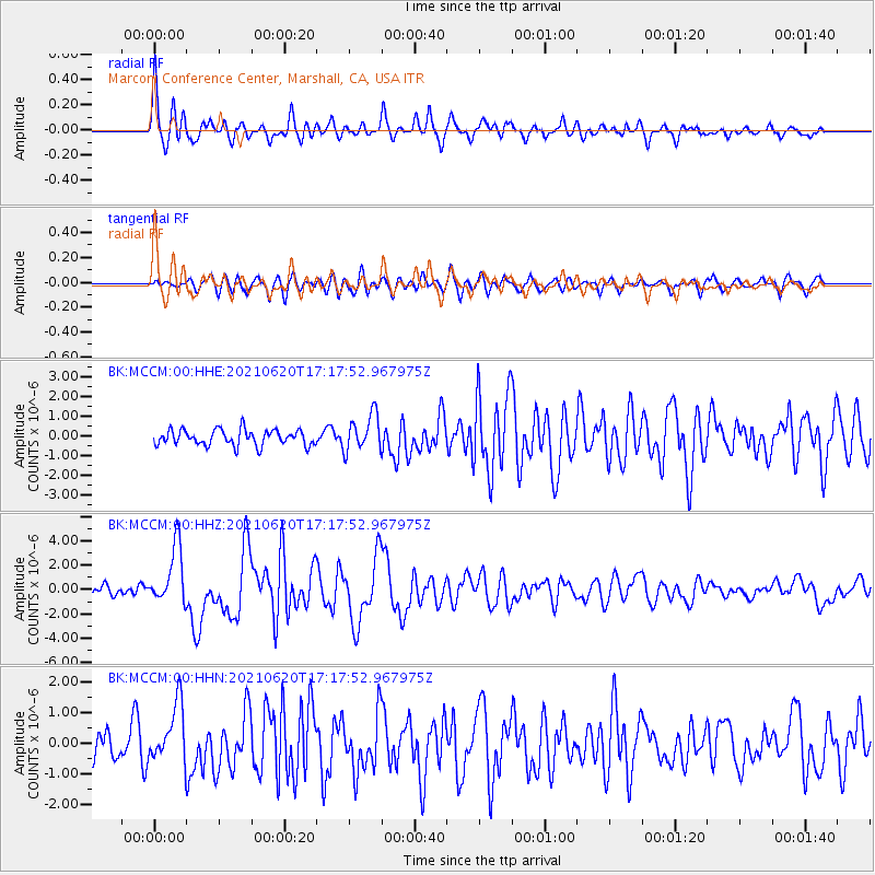
Signal To Noise
| Channel | StoN | STA | LTA |
| BK:MCCM:00:HHZ:20210620T17:17:52.967975Z | 7.0188265 | 2.3757932E-6 | 3.3848866E-7 |
| BK:MCCM:00:HHN:20210620T17:17:52.967975Z | 2.0994935 | 9.444049E-7 | 4.4982514E-7 |
| BK:MCCM:00:HHE:20210620T17:17:52.967975Z | 2.3342721 | 9.215856E-7 | 3.9480636E-7 |
| Arrivals |
| Ps | 3.1 SECOND |
| PpPs | 8.9 SECOND |
| PsPs/PpSs | 12 SECOND |


