You are here: Home > Network List > C1 - Red Sismologica Nacional Stations List
> Station BO02 Daracena > Earthquake Result Viewer
BO02 Daracena - Earthquake Result Viewer
| Earthquake location: |
Kermadec Islands, New Zealand |
| Earthquake latitude/longitude: |
-30.2/-177.8 |
| Earthquake time(UTC): |
2021/06/20 (171) 17:05:48 GMT |
| Earthquake Depth: |
10 km |
| Earthquake Magnitude: |
6.5 mww |
| Earthquake Catalog/Contributor: |
NEIC PDE/us |
|
| Network: |
C1 Red Sismologica Nacional |
| Station: |
BO02 Daracena |
| Lat/Lon: |
34.79 S/70.78 W |
| Elevation: |
886 m |
|
| Distance: |
85.7 deg |
| Az: |
127.89 deg |
| Baz: |
236.106 deg |
| Ray Param: |
0.044609115 |
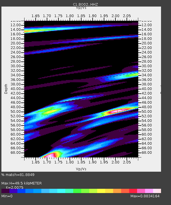
| Estimated Moho Depth: |
49.5 km |
| Estimated Crust Vp/Vs: |
2.01 |
| Assumed Crust Vp: |
6.481 km/s |
| Estimated Crust Vs: |
3.228 km/s |
| Estimated Crust Poisson's Ratio: |
0.33 |
|
| Radial Match: |
81.8849 % |
| Radial Bump: |
400 |
| Transverse Match: |
75.88526 % |
| Transverse Bump: |
400 |
| SOD ConfigId: |
25131211 |
| Insert Time: |
2021-07-04 17:15:24.351 +0000 |
| GWidth: |
2.5 |
| Max Bumps: |
400 |
| Tol: |
0.001 |
|

Signal To Noise
| Channel | StoN | STA | LTA |
| C1:BO02: :HHZ:20210620T17:17:55.398029Z | 5.072476 | 1.4406079E-6 | 2.8400487E-7 |
| C1:BO02: :HHN:20210620T17:17:55.398029Z | 2.1788695 | 4.5546724E-7 | 2.0903835E-7 |
| C1:BO02: :HHE:20210620T17:17:55.398029Z | 7.2780256 | 6.974709E-7 | 9.583243E-8 |
| Arrivals |
| Ps | 7.9 SECOND |
| PpPs | 22 SECOND |
| PsPs/PpSs | 30 SECOND |


