You are here: Home > Network List > KZ - Kazakhstan Network Stations List
> Station KUR Kurchatov, Kazakstan > Earthquake Result Viewer
KUR Kurchatov, Kazakstan - Earthquake Result Viewer
| Earthquake location: |
Greenland Sea |
| Earthquake latitude/longitude: |
79.9/1.9 |
| Earthquake time(UTC): |
1998/03/21 (080) 16:33:11 GMT |
| Earthquake Depth: |
10 km |
| Earthquake Magnitude: |
5.9 MB, 6.1 MS, 6.2 UNKNOWN, 6.2 MW |
| Earthquake Catalog/Contributor: |
WHDF/NEIC |
|
| Network: |
KZ Kazakhstan Network |
| Station: |
KUR Kurchatov, Kazakstan |
| Lat/Lon: |
50.71 N/78.62 E |
| Elevation: |
240 m |
|
| Distance: |
38.2 deg |
| Az: |
90.634 deg |
| Baz: |
343.861 deg |
| Ray Param: |
0.07567957 |
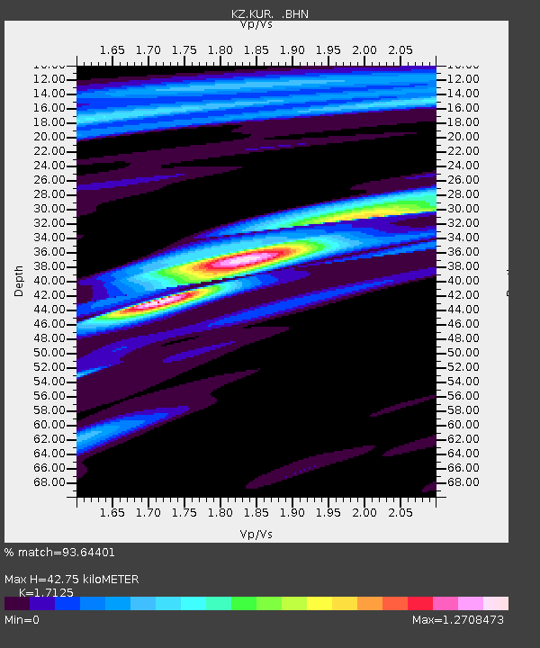
| Estimated Moho Depth: |
42.75 km |
| Estimated Crust Vp/Vs: |
1.71 |
| Assumed Crust Vp: |
6.552 km/s |
| Estimated Crust Vs: |
3.826 km/s |
| Estimated Crust Poisson's Ratio: |
0.24 |
|
| Radial Match: |
93.64401 % |
| Radial Bump: |
309 |
| Transverse Match: |
79.44139 % |
| Transverse Bump: |
400 |
| SOD ConfigId: |
6273 |
| Insert Time: |
2010-03-09 09:27:18.675 +0000 |
| GWidth: |
2.5 |
| Max Bumps: |
400 |
| Tol: |
0.001 |
|

Signal To Noise
| Channel | StoN | STA | LTA |
| KZ:KUR: :BHN:19980321T16:40:00.217987Z | 3.1129498 | 3.928974E-9 | 1.2621386E-9 |
| KZ:KUR: :BHE:19980321T16:40:00.217987Z | 1.4682151 | 1.9527553E-9 | 1.3300199E-9 |
| KZ:KUR: :BHZ:19980321T16:40:00.217987Z | 3.7949216 | 7.2939046E-9 | 1.9220172E-9 |
| Arrivals |
| Ps | 5.0 SECOND |
| PpPs | 16 SECOND |
| PsPs/PpSs | 21 SECOND |


