You are here: Home > Network List > CC - Cascade Chain Volcano Monitoring Stations List
> Station UNFR Upper North Fork Repeater > Earthquake Result Viewer
UNFR Upper North Fork Repeater - Earthquake Result Viewer
| Earthquake location: |
Kermadec Islands, New Zealand |
| Earthquake latitude/longitude: |
-30.2/-177.8 |
| Earthquake time(UTC): |
2021/06/20 (171) 17:05:48 GMT |
| Earthquake Depth: |
10 km |
| Earthquake Magnitude: |
6.5 mww |
| Earthquake Catalog/Contributor: |
NEIC PDE/us |
|
| Network: |
CC Cascade Chain Volcano Monitoring |
| Station: |
UNFR Upper North Fork Repeater |
| Lat/Lon: |
46.27 N/122.29 W |
| Elevation: |
884 m |
|
| Distance: |
91.2 deg |
| Az: |
34.884 deg |
| Baz: |
225.538 deg |
| Ray Param: |
0.041637026 |
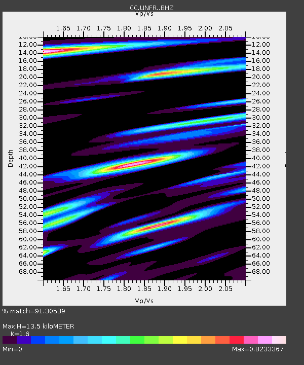
| Estimated Moho Depth: |
13.5 km |
| Estimated Crust Vp/Vs: |
1.60 |
| Assumed Crust Vp: |
6.566 km/s |
| Estimated Crust Vs: |
4.104 km/s |
| Estimated Crust Poisson's Ratio: |
0.18 |
|
| Radial Match: |
91.30539 % |
| Radial Bump: |
352 |
| Transverse Match: |
80.85155 % |
| Transverse Bump: |
400 |
| SOD ConfigId: |
25131211 |
| Insert Time: |
2021-07-04 17:17:26.028 +0000 |
| GWidth: |
2.5 |
| Max Bumps: |
400 |
| Tol: |
0.001 |
|

Signal To Noise
| Channel | StoN | STA | LTA |
| CC:UNFR: :BHZ:20210620T17:18:21.639972Z | 18.393635 | 1.5319879E-6 | 8.3289024E-8 |
| CC:UNFR: :BHN:20210620T17:18:21.639972Z | 4.280949 | 5.1018435E-7 | 1.19175525E-7 |
| CC:UNFR: :BHE:20210620T17:18:21.639972Z | 3.2268739 | 3.4081845E-7 | 1.05618774E-7 |
| Arrivals |
| Ps | 1.3 SECOND |
| PpPs | 5.2 SECOND |
| PsPs/PpSs | 6.5 SECOND |


