You are here: Home > Network List > CI - Caltech Regional Seismic Network Stations List
> Station EDW2 EDW2, Mojave, CA, USA > Earthquake Result Viewer
EDW2 EDW2, Mojave, CA, USA - Earthquake Result Viewer

| Earthquake location: |
Kermadec Islands, New Zealand |
| Earthquake latitude/longitude: |
-30.2/-177.8 |
| Earthquake time(UTC): |
2021/06/20 (171) 17:05:48 GMT |
| Earthquake Depth: |
10 km |
| Earthquake Magnitude: |
6.5 mww |
| Earthquake Catalog/Contributor: |
NEIC PDE/us |
|
| Network: |
CI Caltech Regional Seismic Network |
| Station: |
EDW2 EDW2, Mojave, CA, USA |
| Lat/Lon: |
34.88 N/117.99 W |
| Elevation: |
772 m |
|
| Distance: |
85.8 deg |
| Az: |
45.444 deg |
| Baz: |
228.615 deg |
| Ray Param: |
0.04448786 |
| Estimated Moho Depth: |
45.75 km |
| Estimated Crust Vp/Vs: |
2.04 |
| Assumed Crust Vp: |
6.276 km/s |
| Estimated Crust Vs: |
3.073 km/s |
| Estimated Crust Poisson's Ratio: |
0.34 |
|
| Radial Match: |
95.28179 % |
| Radial Bump: |
382 |
| Transverse Match: |
90.75935 % |
| Transverse Bump: |
400 |
| SOD ConfigId: |
25131211 |
| Insert Time: |
2021-07-04 17:18:00.019 +0000 |
| GWidth: |
2.5 |
| Max Bumps: |
400 |
| Tol: |
0.001 |
|
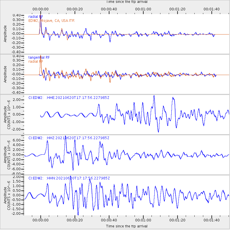
Signal To Noise
| Channel | StoN | STA | LTA |
| CI:EDW2: :HHZ:20210620T17:17:56.227985Z | 10.7833395 | 2.3789764E-6 | 2.2061593E-7 |
| CI:EDW2: :HHN:20210620T17:17:56.227985Z | 2.37345 | 5.0192756E-7 | 2.1147594E-7 |
| CI:EDW2: :HHE:20210620T17:17:56.227985Z | 2.7423055 | 5.704262E-7 | 2.0800972E-7 |
| Arrivals |
| Ps | 7.7 SECOND |
| PpPs | 22 SECOND |
| PsPs/PpSs | 29 SECOND |


