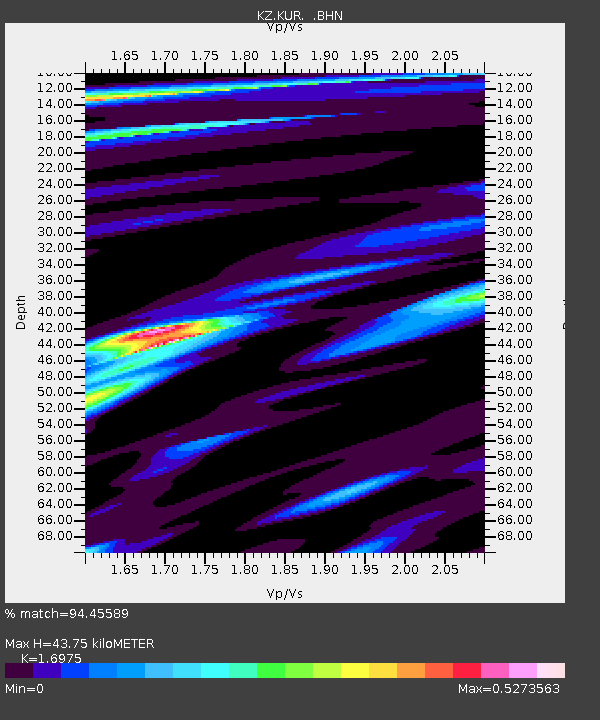
KUR Kurchatov, Kazakstan - Earthquake Result Viewer

Earthquake location: Off East Coast Of Kamchatka
Earthquake latitude/longitude: 52.9/160.1
Earthquake time(UTC): 1998/06/01 (152) 05:34:03 GMT
Earthquake Depth: 44 km
Earthquake Magnitude: 6.2 MB, 6.3 MS, 6.5 UNKNOWN, 6.4 MW
Earthquake Catalog/Contributor: WHDF/NEIC
Network: KZ Kazakhstan Network
Station: KUR Kurchatov, Kazakstan
Lat/Lon: 50.71 N/78.62 E
Elevation: 240 m
Distance: 47.8 deg
Az: 301.979 deg
Baz: 53.949 deg
Ray Param: 0.06964094
Estimated Moho Depth: 43.75 km
Estimated Crust Vp/Vs: 1.70
Assumed Crust Vp: 6.552 km/s
Estimated Crust Vs: 3.86 km/s
Estimated Crust Poisson's Ratio: 0.23
Radial Match: 94.45589 %
Radial Bump: 287
Transverse Match: 71.79097 %
Transverse Bump: 400
SOD ConfigId: 4480
Insert Time: 2010-03-09 09:27:29.090 +0000
GWidth: 2.5
Max Bumps: 400
Tol: 0.001

Signal To Noise

ChannelStoNSTALTA
KZ:KUR: :BHN:19980601T05:42:06.246002Z92.461979.2208026E-89.972535E-10
KZ:KUR: :BHE:19980601T05:42:06.246002Z30.97732.3147658E-87.472458E-10
KZ:KUR: :BHZ:19980601T05:42:06.246002Z58.561684.384682E-87.487289E-10
Arrivals
Ps5.0 SECOND
PpPs17 SECOND
PsPs/PpSs22 SECOND