You are here: Home > Network List > CI - Caltech Regional Seismic Network Stations List
> Station MUR Murrieta > Earthquake Result Viewer
MUR Murrieta - Earthquake Result Viewer

| Earthquake location: |
Kermadec Islands, New Zealand |
| Earthquake latitude/longitude: |
-30.2/-177.8 |
| Earthquake time(UTC): |
2021/06/20 (171) 17:05:48 GMT |
| Earthquake Depth: |
10 km |
| Earthquake Magnitude: |
6.5 mww |
| Earthquake Catalog/Contributor: |
NEIC PDE/us |
|
| Network: |
CI Caltech Regional Seismic Network |
| Station: |
MUR Murrieta |
| Lat/Lon: |
33.60 N/117.20 W |
| Elevation: |
562 m |
|
| Distance: |
85.5 deg |
| Az: |
46.846 deg |
| Baz: |
229.168 deg |
| Ray Param: |
0.044733036 |
| Estimated Moho Depth: |
63.75 km |
| Estimated Crust Vp/Vs: |
1.76 |
| Assumed Crust Vp: |
6.264 km/s |
| Estimated Crust Vs: |
3.549 km/s |
| Estimated Crust Poisson's Ratio: |
0.26 |
|
| Radial Match: |
93.063095 % |
| Radial Bump: |
339 |
| Transverse Match: |
83.46323 % |
| Transverse Bump: |
400 |
| SOD ConfigId: |
25131211 |
| Insert Time: |
2021-07-04 17:18:31.307 +0000 |
| GWidth: |
2.5 |
| Max Bumps: |
400 |
| Tol: |
0.001 |
|
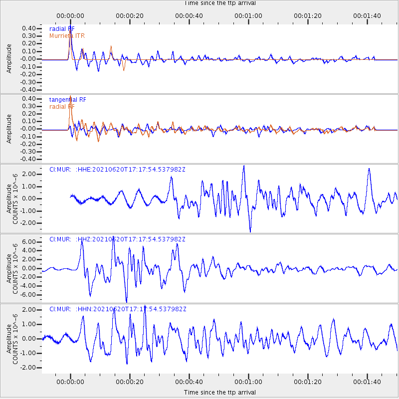
Signal To Noise
| Channel | StoN | STA | LTA |
| CI:MUR: :HHZ:20210620T17:17:54.537982Z | 8.611343 | 2.3907353E-6 | 2.776263E-7 |
| CI:MUR: :HHN:20210620T17:17:54.537982Z | 2.827298 | 6.329963E-7 | 2.2388738E-7 |
| CI:MUR: :HHE:20210620T17:17:54.537982Z | 2.1468635 | 7.164951E-7 | 3.337404E-7 |
| Arrivals |
| Ps | 8.0 SECOND |
| PpPs | 28 SECOND |
| PsPs/PpSs | 35 SECOND |


