You are here: Home > Network List > KZ - Kazakhstan Network Stations List
> Station KUR Kurchatov, Kazakstan > Earthquake Result Viewer
KUR Kurchatov, Kazakstan - Earthquake Result Viewer
| Earthquake location: |
Taiwan Region |
| Earthquake latitude/longitude: |
21.3/122.0 |
| Earthquake time(UTC): |
1998/07/24 (205) 18:44:04 GMT |
| Earthquake Depth: |
33 km |
| Earthquake Magnitude: |
5.6 MB, 5.9 MS, 6.2 UNKNOWN, 6.1 MW |
| Earthquake Catalog/Contributor: |
WHDF/NEIC |
|
| Network: |
KZ Kazakhstan Network |
| Station: |
KUR Kurchatov, Kazakstan |
| Lat/Lon: |
50.71 N/78.62 E |
| Elevation: |
240 m |
|
| Distance: |
44.8 deg |
| Az: |
321.726 deg |
| Baz: |
114.648 deg |
| Ray Param: |
0.07160407 |
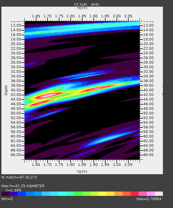
| Estimated Moho Depth: |
42.25 km |
| Estimated Crust Vp/Vs: |
1.70 |
| Assumed Crust Vp: |
6.552 km/s |
| Estimated Crust Vs: |
3.866 km/s |
| Estimated Crust Poisson's Ratio: |
0.23 |
|
| Radial Match: |
97.81272 % |
| Radial Bump: |
311 |
| Transverse Match: |
87.41575 % |
| Transverse Bump: |
400 |
| SOD ConfigId: |
4480 |
| Insert Time: |
2010-03-09 09:27:39.360 +0000 |
| GWidth: |
2.5 |
| Max Bumps: |
400 |
| Tol: |
0.001 |
|

Signal To Noise
| Channel | StoN | STA | LTA |
| KZ:KUR: :BHN:19980724T18:51:44.836005Z | 23.039165 | 2.232419E-8 | 9.689669E-10 |
| KZ:KUR: :BHE:19980724T18:51:44.836005Z | 3.5054555 | 5.6005365E-9 | 1.5976629E-9 |
| KZ:KUR: :BHZ:19980724T18:51:44.836005Z | 14.985913 | 1.1701244E-8 | 7.808163E-10 |
| Arrivals |
| Ps | 4.8 SECOND |
| PpPs | 16 SECOND |
| PsPs/PpSs | 21 SECOND |


