You are here: Home > Network List > CN - Canadian National Seismograph Network Stations List
> Station PTRF Port Renfrew PTRF, BC, CA > Earthquake Result Viewer
PTRF Port Renfrew PTRF, BC, CA - Earthquake Result Viewer
| Earthquake location: |
Kermadec Islands, New Zealand |
| Earthquake latitude/longitude: |
-30.2/-177.8 |
| Earthquake time(UTC): |
2021/06/20 (171) 17:05:48 GMT |
| Earthquake Depth: |
10 km |
| Earthquake Magnitude: |
6.5 mww |
| Earthquake Catalog/Contributor: |
NEIC PDE/us |
|
| Network: |
CN Canadian National Seismograph Network |
| Station: |
PTRF Port Renfrew PTRF, BC, CA |
| Lat/Lon: |
48.54 N/124.41 W |
| Elevation: |
164 m |
|
| Distance: |
91.8 deg |
| Az: |
32.259 deg |
| Baz: |
224.049 deg |
| Ray Param: |
0.04156119 |
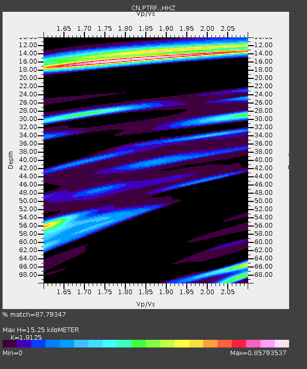
| Estimated Moho Depth: |
15.25 km |
| Estimated Crust Vp/Vs: |
1.81 |
| Assumed Crust Vp: |
6.391 km/s |
| Estimated Crust Vs: |
3.526 km/s |
| Estimated Crust Poisson's Ratio: |
0.28 |
|
| Radial Match: |
87.79347 % |
| Radial Bump: |
294 |
| Transverse Match: |
68.63405 % |
| Transverse Bump: |
392 |
| SOD ConfigId: |
25131211 |
| Insert Time: |
2021-07-04 17:20:14.039 +0000 |
| GWidth: |
2.5 |
| Max Bumps: |
400 |
| Tol: |
0.001 |
|

Signal To Noise
| Channel | StoN | STA | LTA |
| CN:PTRF: :HHZ:20210620T17:18:24.399982Z | 8.244379 | 1.2619366E-6 | 1.5306631E-7 |
| CN:PTRF: :HHN:20210620T17:18:24.399982Z | 2.3483064 | 3.7216614E-7 | 1.5848278E-7 |
| CN:PTRF: :HHE:20210620T17:18:24.399982Z | 1.6948277 | 2.781067E-7 | 1.6409143E-7 |
| Arrivals |
| Ps | 2.0 SECOND |
| PpPs | 6.6 SECOND |
| PsPs/PpSs | 8.6 SECOND |


