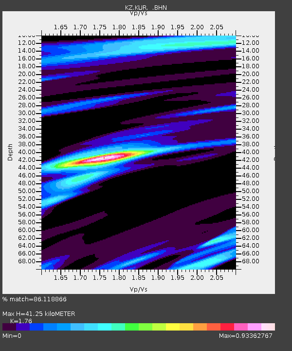
KUR Kurchatov, Kazakstan - Earthquake Result Viewer

Earthquake location: Minahassa Peninsula, Sulawesi
Earthquake latitude/longitude: -0.4/119.9
Earthquake time(UTC): 1998/10/10 (283) 16:29:08 GMT
Earthquake Depth: 33 km
Earthquake Magnitude: 5.5 MS, 5.4 MB, 6.1 UNKNOWN
Earthquake Catalog/Contributor: WHDF/NEIC
Network: KZ Kazakhstan Network
Station: KUR Kurchatov, Kazakstan
Lat/Lon: 50.71 N/78.62 E
Elevation: 240 m
Distance: 61.8 deg
Az: 331.601 deg
Baz: 131.573 deg
Ray Param: 0.060604636
Estimated Moho Depth: 41.25 km
Estimated Crust Vp/Vs: 1.76
Assumed Crust Vp: 6.552 km/s
Estimated Crust Vs: 3.723 km/s
Estimated Crust Poisson's Ratio: 0.26
Radial Match: 86.118866 %
Radial Bump: 400
Transverse Match: 66.452255 %
Transverse Bump: 400
SOD ConfigId: 4480
Insert Time: 2010-03-09 09:28:12.319 +0000
GWidth: 2.5
Max Bumps: 400
Tol: 0.001

Signal To Noise

ChannelStoNSTALTA
KZ:KUR: :BHN:19981010T16:38:52.719995Z2.32625084.168687E-91.7920196E-9
KZ:KUR: :BHE:19981010T16:38:52.719995Z0.458119241.7623591E-93.846944E-9
KZ:KUR: :BHZ:19981010T16:38:52.719995Z1.20892861.8617495E-91.5399997E-9
Arrivals
Ps5.0 SECOND
PpPs17 SECOND
PsPs/PpSs22 SECOND