You are here: Home > Network List > MG - Seismic Network of the NorthEastern Mexico Stations List
> Station TXMV CEIEPAA, FMVZ, UNAM, Tequisquiapan, Queretaro, MEXICO > Earthquake Result Viewer
TXMV CEIEPAA, FMVZ, UNAM, Tequisquiapan, Queretaro, MEXICO - Earthquake Result Viewer
| Earthquake location: |
Kermadec Islands, New Zealand |
| Earthquake latitude/longitude: |
-30.2/-177.8 |
| Earthquake time(UTC): |
2021/06/20 (171) 17:05:48 GMT |
| Earthquake Depth: |
10 km |
| Earthquake Magnitude: |
6.5 mww |
| Earthquake Catalog/Contributor: |
NEIC PDE/us |
|
| Network: |
MG Seismic Network of the NorthEastern Mexico |
| Station: |
TXMV CEIEPAA, FMVZ, UNAM, Tequisquiapan, Queretaro, MEXICO |
| Lat/Lon: |
20.61 N/99.93 W |
| Elevation: |
1908 m |
|
| Distance: |
90.3 deg |
| Az: |
66.334 deg |
| Baz: |
237.818 deg |
| Ray Param: |
0.041713208 |
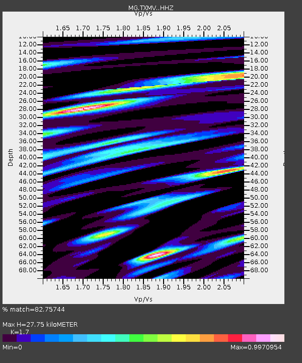
| Estimated Moho Depth: |
27.75 km |
| Estimated Crust Vp/Vs: |
1.70 |
| Assumed Crust Vp: |
6.466 km/s |
| Estimated Crust Vs: |
3.803 km/s |
| Estimated Crust Poisson's Ratio: |
0.24 |
|
| Radial Match: |
82.75744 % |
| Radial Bump: |
400 |
| Transverse Match: |
77.938156 % |
| Transverse Bump: |
400 |
| SOD ConfigId: |
25131211 |
| Insert Time: |
2021-07-04 17:24:01.714 +0000 |
| GWidth: |
2.5 |
| Max Bumps: |
400 |
| Tol: |
0.001 |
|

Signal To Noise
| Channel | StoN | STA | LTA |
| MG:TXMV: :HHZ:20210620T17:18:17.469013Z | 4.905857 | 3.020686E-7 | 6.1573054E-8 |
| MG:TXMV: :HHN:20210620T17:18:17.469013Z | 2.07902 | 7.5332075E-8 | 3.6234415E-8 |
| MG:TXMV: :HHE:20210620T17:18:17.469013Z | 2.1665027 | 1.2794115E-7 | 5.9054234E-8 |
| Arrivals |
| Ps | 3.1 SECOND |
| PpPs | 11 SECOND |
| PsPs/PpSs | 14 SECOND |


