You are here: Home > Network List > IU - Global Seismograph Network (GSN - IRIS/USGS) Stations List
> Station PMG Port Moresby, New Guinea > Earthquake Result Viewer
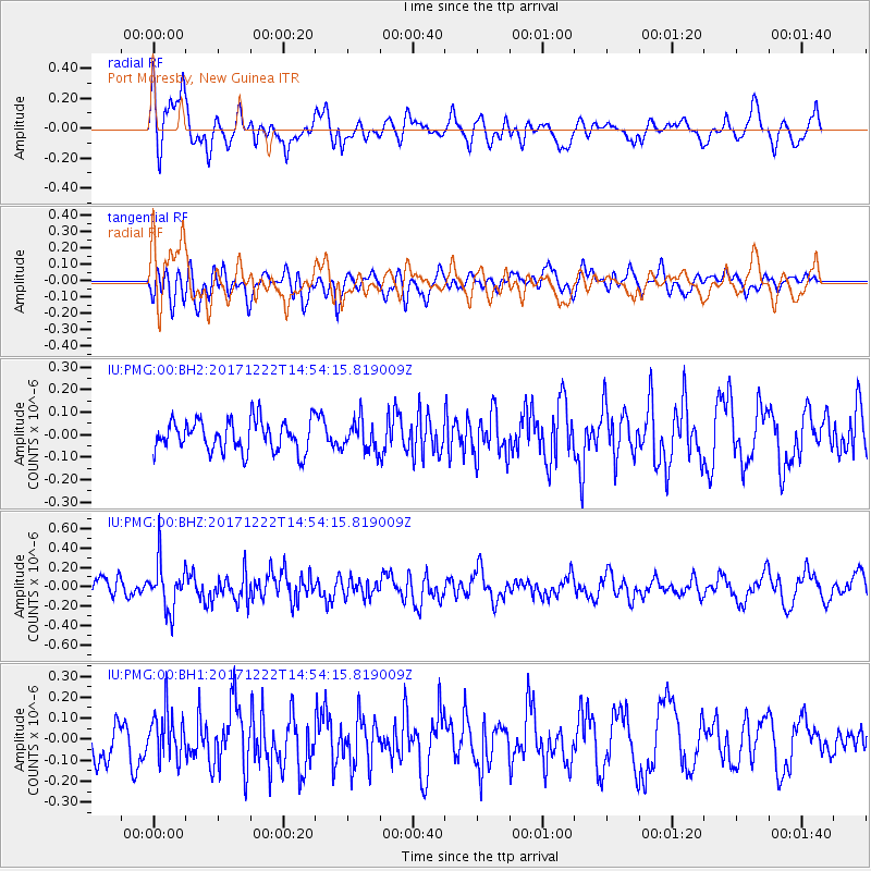
PMG Port Moresby, New Guinea - Earthquake Result Viewer
*The percent match for this event was below the threshold and hence no stack was calculated.
| Earthquake location: |
Near East Coast Of Kamchatka |
| Earthquake latitude/longitude: |
53.8/160.5 |
| Earthquake time(UTC): |
2017/12/22 (356) 14:44:17 GMT |
| Earthquake Depth: |
46 km |
| Earthquake Magnitude: |
5.4 Mww |
| Earthquake Catalog/Contributor: |
NEIC PDE/us |
|
| Network: |
IU Global Seismograph Network (GSN - IRIS/USGS) |
| Station: |
PMG Port Moresby, New Guinea |
| Lat/Lon: |
9.40 S/147.16 E |
| Elevation: |
90 m |
|
| Distance: |
64.0 deg |
| Az: |
194.706 deg |
| Baz: |
8.77 deg |
| Ray Param: |
$rayparam |
*The percent match for this event was below the threshold and hence was not used in the summary stack. |
|
| Radial Match: |
56.55913 % |
| Radial Bump: |
400 |
| Transverse Match: |
48.64372 % |
| Transverse Bump: |
400 |
| SOD ConfigId: |
2429771 |
| Insert Time: |
2018-01-05 14:46:29.712 +0000 |
| GWidth: |
2.5 |
| Max Bumps: |
400 |
| Tol: |
0.001 |
|
Signal To Noise
| Channel | StoN | STA | LTA |
| IU:PMG:00:BHZ:20171222T14:54:15.819009Z | 2.6791234 | 2.4280965E-7 | 9.063026E-8 |
| IU:PMG:00:BH1:20171222T14:54:15.819009Z | 1.2690513 | 1.1368004E-7 | 8.957876E-8 |
| IU:PMG:00:BH2:20171222T14:54:15.819009Z | 0.9771582 | 6.686027E-8 | 6.842318E-8 |
| Arrivals |
| Ps | |
| PpPs | |
| PsPs/PpSs | |


