You are here: Home > Network List > IU - Global Seismograph Network (GSN - IRIS/USGS) Stations List
> Station RSSD Black Hills, South Dakota, USA > Earthquake Result Viewer
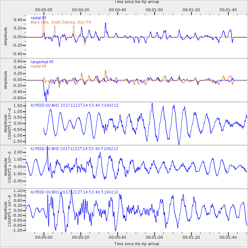
RSSD Black Hills, South Dakota, USA - Earthquake Result Viewer
*The percent match for this event was below the threshold and hence no stack was calculated.
| Earthquake location: |
Near East Coast Of Kamchatka |
| Earthquake latitude/longitude: |
53.8/160.5 |
| Earthquake time(UTC): |
2017/12/22 (356) 14:44:17 GMT |
| Earthquake Depth: |
46 km |
| Earthquake Magnitude: |
5.4 Mww |
| Earthquake Catalog/Contributor: |
NEIC PDE/us |
|
| Network: |
IU Global Seismograph Network (GSN - IRIS/USGS) |
| Station: |
RSSD Black Hills, South Dakota, USA |
| Lat/Lon: |
44.12 N/104.04 W |
| Elevation: |
2090 m |
|
| Distance: |
58.8 deg |
| Az: |
56.972 deg |
| Baz: |
316.374 deg |
| Ray Param: |
$rayparam |
*The percent match for this event was below the threshold and hence was not used in the summary stack. |
|
| Radial Match: |
53.947407 % |
| Radial Bump: |
400 |
| Transverse Match: |
88.51204 % |
| Transverse Bump: |
375 |
| SOD ConfigId: |
2429771 |
| Insert Time: |
2018-01-05 14:46:33.976 +0000 |
| GWidth: |
2.5 |
| Max Bumps: |
400 |
| Tol: |
0.001 |
|
Signal To Noise
| Channel | StoN | STA | LTA |
| IU:RSSD:00:BHZ:20171222T14:53:40.519021Z | 1.6376933 | 9.276928E-7 | 5.664631E-7 |
| IU:RSSD:00:BH1:20171222T14:53:40.519021Z | 1.029828 | 4.7082625E-7 | 4.5718923E-7 |
| IU:RSSD:00:BH2:20171222T14:53:40.519021Z | 0.8753056 | 5.245827E-7 | 5.9931375E-7 |
| Arrivals |
| Ps | |
| PpPs | |
| PsPs/PpSs | |


