You are here: Home > Network List > NN - Western Great Basin/Eastern Sierra Nevada Stations List
> Station MCM05 Monte Cristo Menlo 05 > Earthquake Result Viewer
MCM05 Monte Cristo Menlo 05 - Earthquake Result Viewer
| Earthquake location: |
Kermadec Islands, New Zealand |
| Earthquake latitude/longitude: |
-30.2/-177.8 |
| Earthquake time(UTC): |
2021/06/20 (171) 17:05:48 GMT |
| Earthquake Depth: |
10 km |
| Earthquake Magnitude: |
6.5 mww |
| Earthquake Catalog/Contributor: |
NEIC PDE/us |
|
| Network: |
NN Western Great Basin/Eastern Sierra Nevada |
| Station: |
MCM05 Monte Cristo Menlo 05 |
| Lat/Lon: |
38.16 N/117.87 W |
| Elevation: |
1591 m |
|
| Distance: |
88.1 deg |
| Az: |
43.054 deg |
| Baz: |
228.559 deg |
| Ray Param: |
0.042867947 |
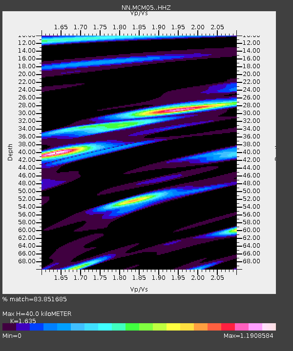
| Estimated Moho Depth: |
40.0 km |
| Estimated Crust Vp/Vs: |
1.63 |
| Assumed Crust Vp: |
6.276 km/s |
| Estimated Crust Vs: |
3.838 km/s |
| Estimated Crust Poisson's Ratio: |
0.20 |
|
| Radial Match: |
83.851685 % |
| Radial Bump: |
400 |
| Transverse Match: |
77.881004 % |
| Transverse Bump: |
400 |
| SOD ConfigId: |
25131211 |
| Insert Time: |
2021-07-04 17:24:41.719 +0000 |
| GWidth: |
2.5 |
| Max Bumps: |
400 |
| Tol: |
0.001 |
|

Signal To Noise
| Channel | StoN | STA | LTA |
| NN:MCM05: :HHZ:20210620T17:18:07.07497Z | 10.541364 | 1.6689561E-6 | 1.5832448E-7 |
| NN:MCM05: :HHN:20210620T17:18:07.07497Z | 2.3871567 | 3.2722696E-7 | 1.3707812E-7 |
| NN:MCM05: :HHE:20210620T17:18:07.07497Z | 3.9716258 | 5.736518E-7 | 1.4443752E-7 |
| Arrivals |
| Ps | 4.1 SECOND |
| PpPs | 16 SECOND |
| PsPs/PpSs | 21 SECOND |


