You are here: Home > Network List > NN - Western Great Basin/Eastern Sierra Nevada Stations List
> Station WDEM Washoe County DEM, Nevada > Earthquake Result Viewer
WDEM Washoe County DEM, Nevada - Earthquake Result Viewer
| Earthquake location: |
Kermadec Islands, New Zealand |
| Earthquake latitude/longitude: |
-30.2/-177.8 |
| Earthquake time(UTC): |
2021/06/20 (171) 17:05:48 GMT |
| Earthquake Depth: |
10 km |
| Earthquake Magnitude: |
6.5 mww |
| Earthquake Catalog/Contributor: |
NEIC PDE/us |
|
| Network: |
NN Western Great Basin/Eastern Sierra Nevada |
| Station: |
WDEM Washoe County DEM, Nevada |
| Lat/Lon: |
39.58 N/119.81 W |
| Elevation: |
1572 m |
|
| Distance: |
87.9 deg |
| Az: |
40.982 deg |
| Baz: |
227.275 deg |
| Ray Param: |
0.042992484 |
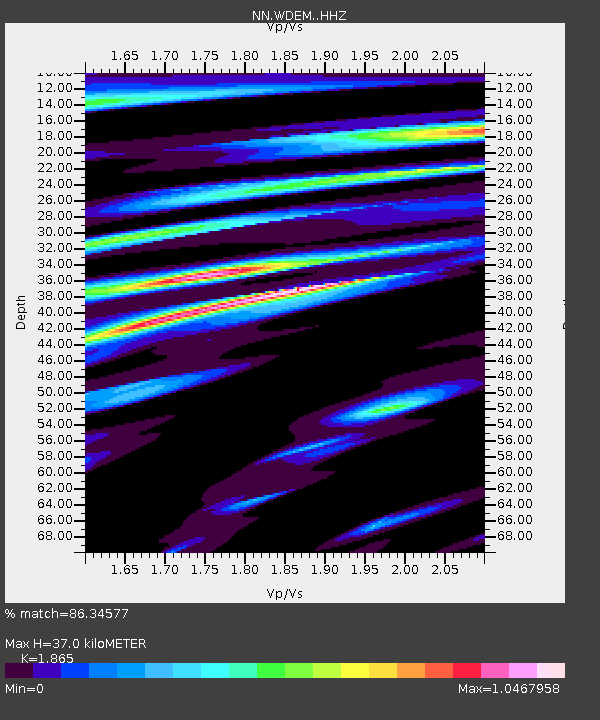
| Estimated Moho Depth: |
37.0 km |
| Estimated Crust Vp/Vs: |
1.87 |
| Assumed Crust Vp: |
6.279 km/s |
| Estimated Crust Vs: |
3.367 km/s |
| Estimated Crust Poisson's Ratio: |
0.30 |
|
| Radial Match: |
86.34577 % |
| Radial Bump: |
400 |
| Transverse Match: |
53.26229 % |
| Transverse Bump: |
400 |
| SOD ConfigId: |
25131211 |
| Insert Time: |
2021-07-04 17:25:11.746 +0000 |
| GWidth: |
2.5 |
| Max Bumps: |
400 |
| Tol: |
0.001 |
|

Signal To Noise
| Channel | StoN | STA | LTA |
| NN:WDEM: :HHZ:20210620T17:18:06.277973Z | 14.667773 | 1.7212204E-6 | 1.17347085E-7 |
| NN:WDEM: :HHN:20210620T17:18:06.277973Z | 1.8040372 | 7.2510267E-7 | 4.0193333E-7 |
| NN:WDEM: :HHE:20210620T17:18:06.277973Z | 2.2630475 | 3.983181E-7 | 1.760096E-7 |
| Arrivals |
| Ps | 5.2 SECOND |
| PpPs | 17 SECOND |
| PsPs/PpSs | 22 SECOND |


