You are here: Home > Network List > KZ - Kazakhstan Network Stations List
> Station KUR Kurchatov, Kazakstan > Earthquake Result Viewer
KUR Kurchatov, Kazakstan - Earthquake Result Viewer
| Earthquake location: |
New Ireland Region, P.N.G. |
| Earthquake latitude/longitude: |
-4.6/153.7 |
| Earthquake time(UTC): |
1999/01/28 (028) 18:24:25 GMT |
| Earthquake Depth: |
101 km |
| Earthquake Magnitude: |
5.6 MB, 6.4 MW, 6.3 MW |
| Earthquake Catalog/Contributor: |
WHDF/NEIC |
|
| Network: |
KZ Kazakhstan Network |
| Station: |
KUR Kurchatov, Kazakstan |
| Lat/Lon: |
50.71 N/78.62 E |
| Elevation: |
240 m |
|
| Distance: |
84.1 deg |
| Az: |
321.872 deg |
| Baz: |
104.503 deg |
| Ray Param: |
0.04548877 |
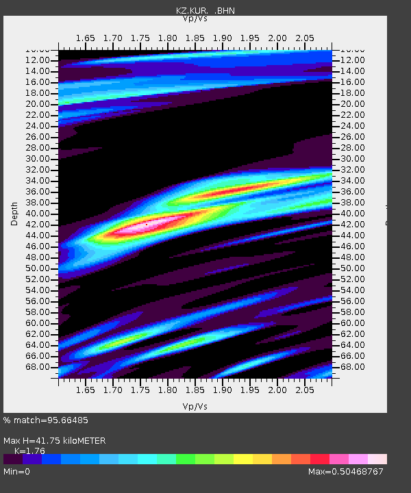
| Estimated Moho Depth: |
41.75 km |
| Estimated Crust Vp/Vs: |
1.76 |
| Assumed Crust Vp: |
6.552 km/s |
| Estimated Crust Vs: |
3.723 km/s |
| Estimated Crust Poisson's Ratio: |
0.26 |
|
| Radial Match: |
95.66485 % |
| Radial Bump: |
386 |
| Transverse Match: |
84.05615 % |
| Transverse Bump: |
400 |
| SOD ConfigId: |
4480 |
| Insert Time: |
2010-03-09 09:29:01.749 +0000 |
| GWidth: |
2.5 |
| Max Bumps: |
400 |
| Tol: |
0.001 |
|

Signal To Noise
| Channel | StoN | STA | LTA |
| KZ:KUR: :BHN:19990128T18:36:13.921001Z | 15.022565 | 2.640981E-8 | 1.7580093E-9 |
| KZ:KUR: :BHE:19990128T18:36:13.921001Z | 1.7275419 | 2.5096023E-9 | 1.4527013E-9 |
| KZ:KUR: :BHZ:19990128T18:36:13.921001Z | 5.1041846 | 8.957227E-9 | 1.7548791E-9 |
| Arrivals |
| Ps | 5.0 SECOND |
| PpPs | 17 SECOND |
| PsPs/PpSs | 22 SECOND |


