You are here: Home > Network List > UO - University of Oregon Regional Network Stations List
> Station MARQ Marquam, OR, USA > Earthquake Result Viewer
MARQ Marquam, OR, USA - Earthquake Result Viewer
| Earthquake location: |
Kermadec Islands, New Zealand |
| Earthquake latitude/longitude: |
-30.2/-177.8 |
| Earthquake time(UTC): |
2021/06/20 (171) 17:05:48 GMT |
| Earthquake Depth: |
10 km |
| Earthquake Magnitude: |
6.5 mww |
| Earthquake Catalog/Contributor: |
NEIC PDE/us |
|
| Network: |
UO University of Oregon Regional Network |
| Station: |
MARQ Marquam, OR, USA |
| Lat/Lon: |
45.07 N/122.67 W |
| Elevation: |
159 m |
|
| Distance: |
90.2 deg |
| Az: |
35.558 deg |
| Baz: |
225.262 deg |
| Ray Param: |
0.041719988 |
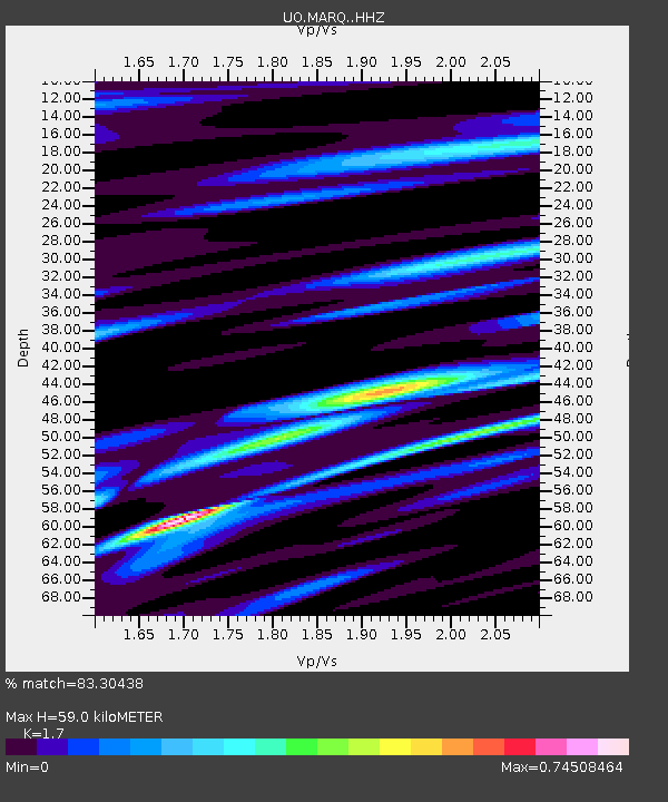
| Estimated Moho Depth: |
59.0 km |
| Estimated Crust Vp/Vs: |
1.70 |
| Assumed Crust Vp: |
6.566 km/s |
| Estimated Crust Vs: |
3.862 km/s |
| Estimated Crust Poisson's Ratio: |
0.24 |
|
| Radial Match: |
83.30438 % |
| Radial Bump: |
400 |
| Transverse Match: |
74.96432 % |
| Transverse Bump: |
400 |
| SOD ConfigId: |
25131211 |
| Insert Time: |
2021-07-04 17:30:05.624 +0000 |
| GWidth: |
2.5 |
| Max Bumps: |
400 |
| Tol: |
0.001 |
|

Signal To Noise
| Channel | StoN | STA | LTA |
| UO:MARQ: :HHZ:20210620T17:18:16.849994Z | 8.657575 | 1.8109523E-6 | 2.0917547E-7 |
| UO:MARQ: :HHN:20210620T17:18:16.849994Z | 1.8315173 | 3.2607468E-7 | 1.7803528E-7 |
| UO:MARQ: :HHE:20210620T17:18:16.849994Z | 1.8792914 | 3.6581653E-7 | 1.9465662E-7 |
| Arrivals |
| Ps | 6.4 SECOND |
| PpPs | 24 SECOND |
| PsPs/PpSs | 30 SECOND |


