You are here: Home > Network List > UU - University of Utah Regional Network Stations List
> Station FORU South Mineral Mountains, UT, USA > Earthquake Result Viewer
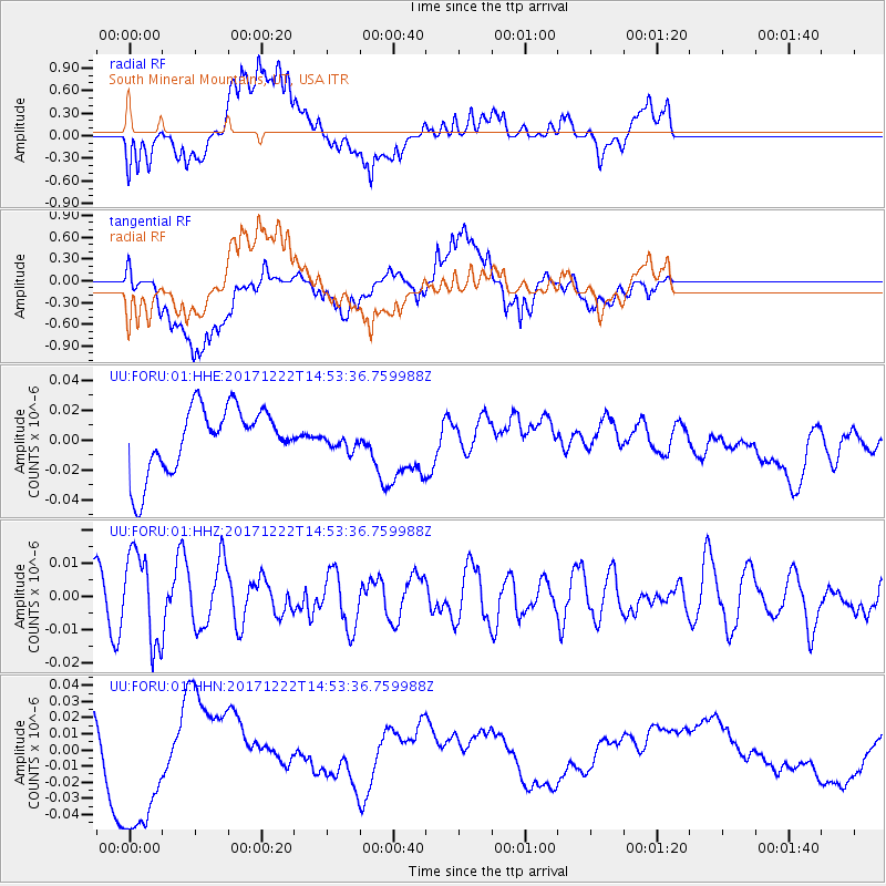
FORU South Mineral Mountains, UT, USA - Earthquake Result Viewer
*The percent match for this event was below the threshold and hence no stack was calculated.
| Earthquake location: |
Near East Coast Of Kamchatka |
| Earthquake latitude/longitude: |
53.8/160.5 |
| Earthquake time(UTC): |
2017/12/22 (356) 14:44:17 GMT |
| Earthquake Depth: |
46 km |
| Earthquake Magnitude: |
5.4 Mww |
| Earthquake Catalog/Contributor: |
NEIC PDE/us |
|
| Network: |
UU University of Utah Regional Network |
| Station: |
FORU South Mineral Mountains, UT, USA |
| Lat/Lon: |
38.46 N/112.86 W |
| Elevation: |
1840 m |
|
| Distance: |
58.2 deg |
| Az: |
67.185 deg |
| Baz: |
315.905 deg |
| Ray Param: |
$rayparam |
*The percent match for this event was below the threshold and hence was not used in the summary stack. |
|
| Radial Match: |
36.160324 % |
| Radial Bump: |
400 |
| Transverse Match: |
40.799744 % |
| Transverse Bump: |
400 |
| SOD ConfigId: |
2429771 |
| Insert Time: |
2018-01-05 14:49:07.078 +0000 |
| GWidth: |
2.5 |
| Max Bumps: |
400 |
| Tol: |
0.001 |
|
Signal To Noise
| Channel | StoN | STA | LTA |
| UU:FORU:01:HHZ:20171222T14:53:36.759988Z | 2.3902411 | 1.3258177E-8 | 5.5467946E-9 |
| UU:FORU:01:HHN:20171222T14:53:36.759988Z | 2.4486408 | 4.546137E-8 | 1.8565961E-8 |
| UU:FORU:01:HHE:20171222T14:53:36.759988Z | 0.2800209 | 6.0811582E-9 | 2.17168E-8 |
| Arrivals |
| Ps | |
| PpPs | |
| PsPs/PpSs | |


