You are here: Home > Network List > GS - US Geological Survey Networks Stations List
> Station KAN09 Caldwell North Station > Earthquake Result Viewer
KAN09 Caldwell North Station - Earthquake Result Viewer
| Earthquake location: |
Leeward Islands |
| Earthquake latitude/longitude: |
18.3/-62.7 |
| Earthquake time(UTC): |
2017/12/24 (358) 15:12:51 GMT |
| Earthquake Depth: |
63 km |
| Earthquake Magnitude: |
5.5 Mi |
| Earthquake Catalog/Contributor: |
NEIC PDE/pt |
|
| Network: |
GS US Geological Survey Networks |
| Station: |
KAN09 Caldwell North Station |
| Lat/Lon: |
37.14 N/97.62 W |
| Elevation: |
371 m |
|
| Distance: |
35.9 deg |
| Az: |
308.692 deg |
| Baz: |
111.907 deg |
| Ray Param: |
0.0768142 |
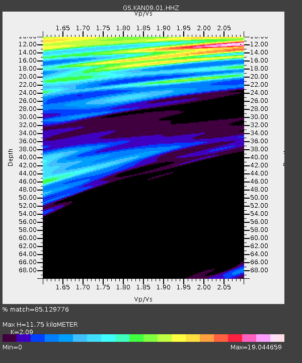
| Estimated Moho Depth: |
11.75 km |
| Estimated Crust Vp/Vs: |
2.09 |
| Assumed Crust Vp: |
6.483 km/s |
| Estimated Crust Vs: |
3.102 km/s |
| Estimated Crust Poisson's Ratio: |
0.35 |
|
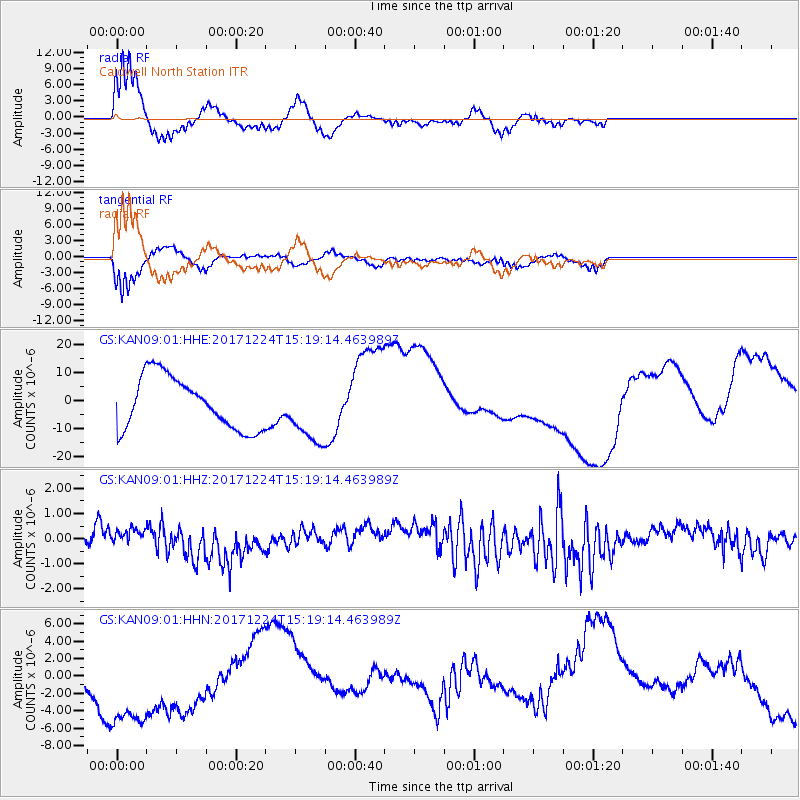
| Radial Match: |
85.129776 % |
| Radial Bump: |
400 |
| Transverse Match: |
87.32296 % |
| Transverse Bump: |
400 |
| SOD ConfigId: |
2429771 |
| Insert Time: |
2018-01-07 15:13:40.397 +0000 |
| GWidth: |
2.5 |
| Max Bumps: |
400 |
| Tol: |
0.001 |
|
Signal To Noise
| Channel | StoN | STA | LTA |
| GS:KAN09:01:HHZ:20171224T15:19:14.463989Z | 0.78469825 | 3.1680923E-7 | 4.0373388E-7 |
| GS:KAN09:01:HHN:20171224T15:19:14.463989Z | 3.3802845 | 8.190639E-6 | 2.423062E-6 |
| GS:KAN09:01:HHE:20171224T15:19:14.463989Z | 1.1986176 | 1.1223963E-5 | 9.36409E-6 |
| Arrivals |
| Ps | 2.1 SECOND |
| PpPs | 5.3 SECOND |
| PsPs/PpSs | 7.4 SECOND |


