You are here: Home > Network List > AV - Alaska Volcano Observatory Stations List
> Station MAPS Pakushin Southeast, Makushin Volcano, Alaska > Earthquake Result Viewer
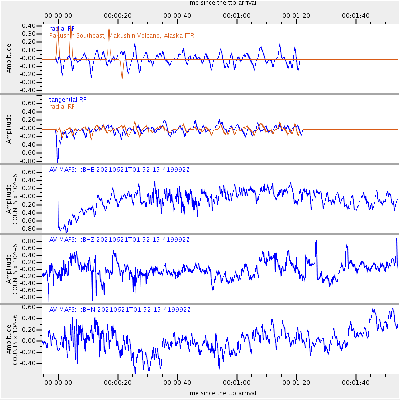
MAPS Pakushin Southeast, Makushin Volcano, Alaska - Earthquake Result Viewer
*The percent match for this event was below the threshold and hence no stack was calculated.
| Earthquake location: |
Mariana Islands |
| Earthquake latitude/longitude: |
18.9/145.4 |
| Earthquake time(UTC): |
2021/06/21 (172) 01:44:11 GMT |
| Earthquake Depth: |
227 km |
| Earthquake Magnitude: |
5.5 mww |
| Earthquake Catalog/Contributor: |
NEIC PDE/us |
|
| Network: |
AV Alaska Volcano Observatory |
| Station: |
MAPS Pakushin Southeast, Makushin Volcano, Alaska |
| Lat/Lon: |
53.81 N/166.94 W |
| Elevation: |
333 m |
|
| Distance: |
50.4 deg |
| Az: |
34.664 deg |
| Baz: |
245.235 deg |
| Ray Param: |
$rayparam |
*The percent match for this event was below the threshold and hence was not used in the summary stack. |
|
| Radial Match: |
43.357185 % |
| Radial Bump: |
400 |
| Transverse Match: |
74.19295 % |
| Transverse Bump: |
288 |
| SOD ConfigId: |
25131211 |
| Insert Time: |
2021-07-05 01:47:15.342 +0000 |
| GWidth: |
2.5 |
| Max Bumps: |
400 |
| Tol: |
0.001 |
|
Signal To Noise
| Channel | StoN | STA | LTA |
| AV:MAPS: :BHZ:20210621T01:52:15.419992Z | 1.0075903 | 2.9795672E-7 | 2.957122E-7 |
| AV:MAPS: :BHN:20210621T01:52:15.419992Z | 1.1457368 | 4.5827062E-7 | 3.9997897E-7 |
| AV:MAPS: :BHE:20210621T01:52:15.419992Z | 1.0963566 | 3.1123852E-7 | 2.838844E-7 |
| Arrivals |
| Ps | |
| PpPs | |
| PsPs/PpSs | |


