You are here: Home > Network List > US - United States National Seismic Network Stations List
> Station EGMT Eagleton, Montana, USA > Earthquake Result Viewer
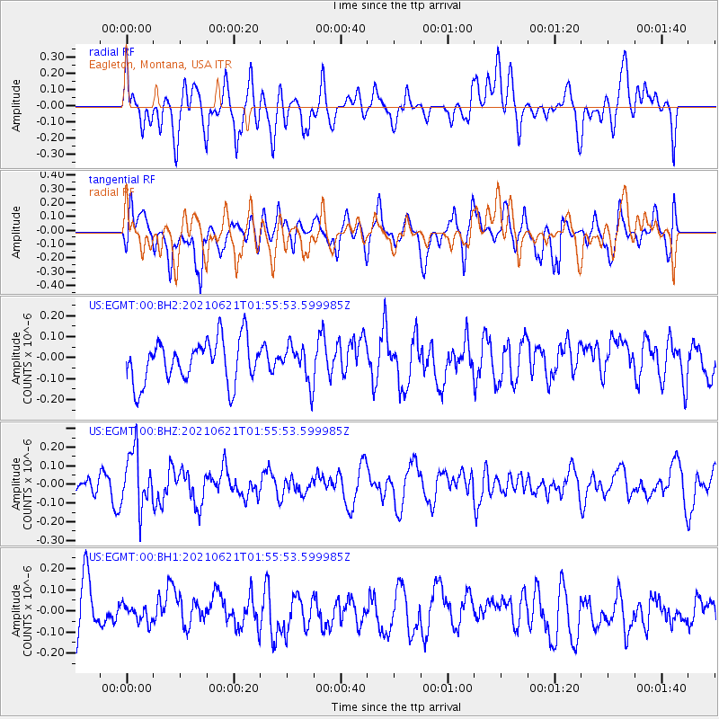
EGMT Eagleton, Montana, USA - Earthquake Result Viewer
*The percent match for this event was below the threshold and hence no stack was calculated.
| Earthquake location: |
Mariana Islands |
| Earthquake latitude/longitude: |
18.9/145.4 |
| Earthquake time(UTC): |
2021/06/21 (172) 01:44:11 GMT |
| Earthquake Depth: |
227 km |
| Earthquake Magnitude: |
5.5 mww |
| Earthquake Catalog/Contributor: |
NEIC PDE/us |
|
| Network: |
US United States National Seismic Network |
| Station: |
EGMT Eagleton, Montana, USA |
| Lat/Lon: |
48.02 N/109.75 W |
| Elevation: |
1055 m |
|
| Distance: |
85.7 deg |
| Az: |
40.602 deg |
| Baz: |
293.376 deg |
| Ray Param: |
$rayparam |
*The percent match for this event was below the threshold and hence was not used in the summary stack. |
|
| Radial Match: |
45.803143 % |
| Radial Bump: |
400 |
| Transverse Match: |
54.270798 % |
| Transverse Bump: |
400 |
| SOD ConfigId: |
25131211 |
| Insert Time: |
2021-07-05 01:56:39.592 +0000 |
| GWidth: |
2.5 |
| Max Bumps: |
400 |
| Tol: |
0.001 |
|
Signal To Noise
| Channel | StoN | STA | LTA |
| US:EGMT:00:BHZ:20210621T01:55:53.599985Z | 2.45165 | 1.5176141E-7 | 6.190175E-8 |
| US:EGMT:00:BH1:20210621T01:55:53.599985Z | 0.30173916 | 3.9835363E-8 | 1.320192E-7 |
| US:EGMT:00:BH2:20210621T01:55:53.599985Z | 0.87106824 | 8.865455E-8 | 1.0177682E-7 |
| Arrivals |
| Ps | |
| PpPs | |
| PsPs/PpSs | |


