You are here: Home > Network List > UW - Pacific Northwest Regional Seismic Network Stations List
> Station UMAT Pilot Rock, OR, USA > Earthquake Result Viewer
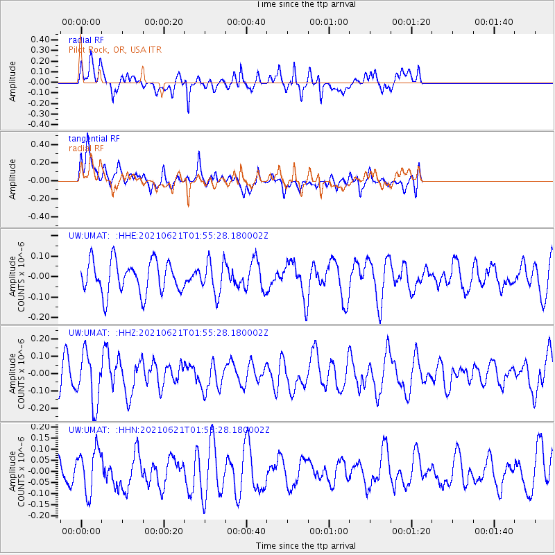
UMAT Pilot Rock, OR, USA - Earthquake Result Viewer
*The percent match for this event was below the threshold and hence no stack was calculated.
| Earthquake location: |
Mariana Islands |
| Earthquake latitude/longitude: |
18.9/145.4 |
| Earthquake time(UTC): |
2021/06/21 (172) 01:44:11 GMT |
| Earthquake Depth: |
227 km |
| Earthquake Magnitude: |
5.5 mww |
| Earthquake Catalog/Contributor: |
NEIC PDE/us |
|
| Network: |
UW Pacific Northwest Regional Seismic Network |
| Station: |
UMAT Pilot Rock, OR, USA |
| Lat/Lon: |
45.29 N/118.96 W |
| Elevation: |
1318 m |
|
| Distance: |
80.7 deg |
| Az: |
45.393 deg |
| Baz: |
287.266 deg |
| Ray Param: |
$rayparam |
*The percent match for this event was below the threshold and hence was not used in the summary stack. |
|
| Radial Match: |
52.443672 % |
| Radial Bump: |
390 |
| Transverse Match: |
51.239582 % |
| Transverse Bump: |
400 |
| SOD ConfigId: |
25131211 |
| Insert Time: |
2021-07-05 01:57:55.627 +0000 |
| GWidth: |
2.5 |
| Max Bumps: |
400 |
| Tol: |
0.001 |
|
Signal To Noise
| Channel | StoN | STA | LTA |
| UW:UMAT: :HHZ:20210621T01:55:28.180002Z | 2.3891885 | 1.5049694E-7 | 6.2990814E-8 |
| UW:UMAT: :HHN:20210621T01:55:28.180002Z | 1.3005258 | 9.744632E-8 | 7.49284E-8 |
| UW:UMAT: :HHE:20210621T01:55:28.180002Z | 1.03385 | 8.1698595E-8 | 7.902365E-8 |
| Arrivals |
| Ps | |
| PpPs | |
| PsPs/PpSs | |


