You are here: Home > Network List > WY - Yellowstone Wyoming Seismic Network Stations List
> Station YEE East Entrance, YNP, WY, USA > Earthquake Result Viewer
YEE East Entrance, YNP, WY, USA - Earthquake Result Viewer
| Earthquake location: |
Kermadec Islands, New Zealand |
| Earthquake latitude/longitude: |
-30.3/-177.5 |
| Earthquake time(UTC): |
2021/06/21 (172) 11:14:12 GMT |
| Earthquake Depth: |
27 km |
| Earthquake Magnitude: |
6.0 mww |
| Earthquake Catalog/Contributor: |
NEIC PDE/us |
|
| Network: |
WY Yellowstone Wyoming Seismic Network |
| Station: |
YEE East Entrance, YNP, WY, USA |
| Lat/Lon: |
44.49 N/109.90 W |
| Elevation: |
2270 m |
|
| Distance: |
96.6 deg |
| Az: |
41.754 deg |
| Baz: |
233.552 deg |
| Ray Param: |
0.04046397 |
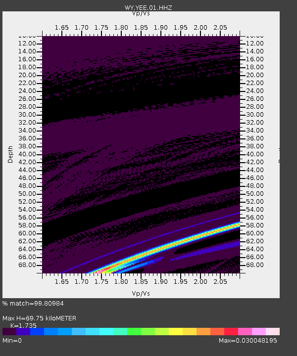
| Estimated Moho Depth: |
69.75 km |
| Estimated Crust Vp/Vs: |
1.74 |
| Assumed Crust Vp: |
6.242 km/s |
| Estimated Crust Vs: |
3.598 km/s |
| Estimated Crust Poisson's Ratio: |
0.25 |
|
| Radial Match: |
99.80984 % |
| Radial Bump: |
9 |
| Transverse Match: |
99.99273 % |
| Transverse Bump: |
2 |
| SOD ConfigId: |
25131211 |
| Insert Time: |
2021-07-05 11:27:40.746 +0000 |
| GWidth: |
2.5 |
| Max Bumps: |
400 |
| Tol: |
0.001 |
|

Signal To Noise
| Channel | StoN | STA | LTA |
| WY:YEE:01:HHZ:20210621T11:27:07.85002Z | 1.7632293 | 1.3089752E-7 | 7.423738E-8 |
| WY:YEE:01:HHN:20210621T11:27:07.85002Z | 1.7649534 | 1.602598E-7 | 9.080116E-8 |
| WY:YEE:01:HHE:20210621T11:27:07.85002Z | 0.7595513 | 2.9801304E-9 | 3.9235406E-9 |
| Arrivals |
| Ps | 8.4 SECOND |
| PpPs | 30 SECOND |
| PsPs/PpSs | 38 SECOND |


