You are here: Home > Network List > KZ - Kazakhstan Network Stations List
> Station KURK Kurchatov, Kazakhstan > Earthquake Result Viewer
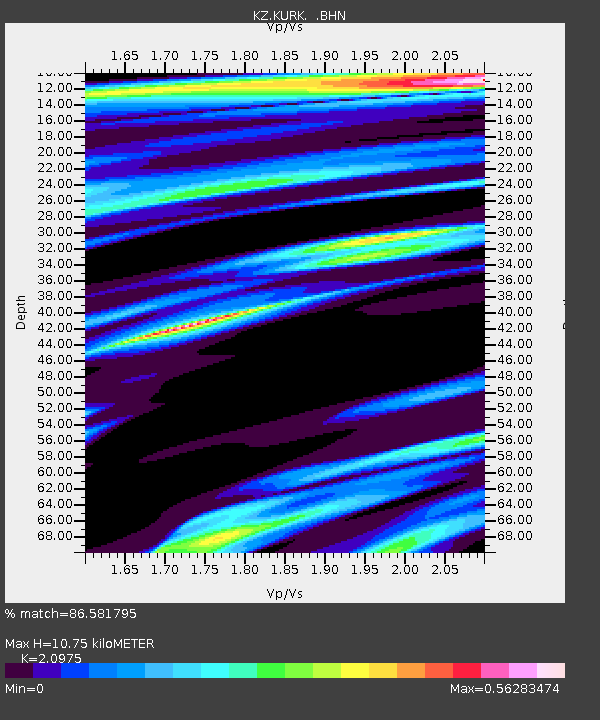
KURK Kurchatov, Kazakhstan - Earthquake Result Viewer
| Earthquake location: |
Mariana Islands |
| Earthquake latitude/longitude: |
17.7/145.4 |
| Earthquake time(UTC): |
2000/02/15 (046) 02:05:00 GMT |
| Earthquake Depth: |
522 km |
| Earthquake Magnitude: |
5.9 MB, 5.9 MW, 5.8 MW |
| Earthquake Catalog/Contributor: |
WHDF/NEIC |
|
| Network: |
KZ Kazakhstan Network |
| Station: |
KURK Kurchatov, Kazakhstan |
| Lat/Lon: |
50.72 N/78.62 E |
| Elevation: |
184 m |
|
| Distance: |
61.8 deg |
| Az: |
318.498 deg |
| Baz: |
96.402 deg |
| Ray Param: |
0.05866383 |
| Estimated Moho Depth: |
10.75 km |
| Estimated Crust Vp/Vs: |
2.10 |
| Assumed Crust Vp: |
6.552 km/s |
| Estimated Crust Vs: |
3.124 km/s |
| Estimated Crust Poisson's Ratio: |
0.35 |
|
| Radial Match: |
86.581795 % |
| Radial Bump: |
400 |
| Transverse Match: |
72.97695 % |
| Transverse Bump: |
400 |
| SOD ConfigId: |
3753 |
| Insert Time: |
2010-03-09 09:31:36.373 +0000 |
| GWidth: |
2.5 |
| Max Bumps: |
400 |
| Tol: |
0.001 |
|

Signal To Noise
| Channel | StoN | STA | LTA |
| KZ:KURK: :BHN:20000215T02:13:57.762014Z | 2.528578 | 2.942922E-7 | 1.1638643E-7 |
| KZ:KURK: :BHE:20000215T02:13:57.762014Z | 26.922232 | 1.9989059E-6 | 7.42474E-8 |
| KZ:KURK: :BHZ:20000215T02:13:57.762014Z | 31.419064 | 4.8928787E-6 | 1.5572962E-7 |
| Arrivals |
| Ps | 1.9 SECOND |
| PpPs | 4.9 SECOND |
| PsPs/PpSs | 6.8 SECOND |


