You are here: Home > Network List > KZ - Kazakhstan Network Stations List
> Station KURK Kurchatov, Kazakhstan > Earthquake Result Viewer
KURK Kurchatov, Kazakhstan - Earthquake Result Viewer
| Earthquake location: |
Java, Indonesia |
| Earthquake latitude/longitude: |
-8.6/110.6 |
| Earthquake time(UTC): |
2001/10/14 (287) 01:10:45 GMT |
| Earthquake Depth: |
67 km |
| Earthquake Magnitude: |
5.6 MB, 5.3 MS, 5.9 MW, 5.8 MW |
| Earthquake Catalog/Contributor: |
WHDF/NEIC |
|
| Network: |
KZ Kazakhstan Network |
| Station: |
KURK Kurchatov, Kazakhstan |
| Lat/Lon: |
50.72 N/78.62 E |
| Elevation: |
184 m |
|
| Distance: |
65.3 deg |
| Az: |
338.22 deg |
| Baz: |
144.747 deg |
| Ray Param: |
0.058224857 |
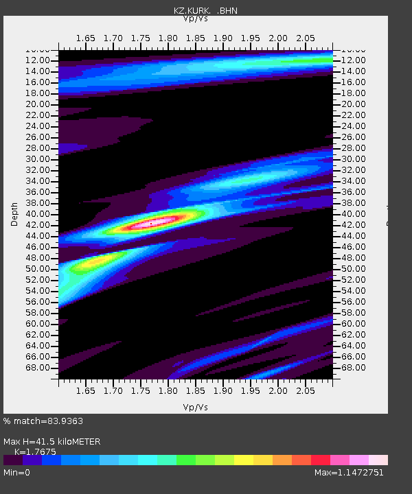
| Estimated Moho Depth: |
41.5 km |
| Estimated Crust Vp/Vs: |
1.77 |
| Assumed Crust Vp: |
6.552 km/s |
| Estimated Crust Vs: |
3.707 km/s |
| Estimated Crust Poisson's Ratio: |
0.26 |
|
| Radial Match: |
83.9363 % |
| Radial Bump: |
400 |
| Transverse Match: |
69.53096 % |
| Transverse Bump: |
400 |
| SOD ConfigId: |
20082 |
| Insert Time: |
2010-03-09 09:31:54.009 +0000 |
| GWidth: |
2.5 |
| Max Bumps: |
400 |
| Tol: |
0.001 |
|

Signal To Noise
| Channel | StoN | STA | LTA |
| KZ:KURK: :BHN:20011014T01:20:49.492019Z | 6.768404 | 7.0674344E-7 | 1.04418035E-7 |
| KZ:KURK: :BHE:20011014T01:20:49.492019Z | 5.5648146 | 5.391991E-7 | 9.6894354E-8 |
| KZ:KURK: :BHZ:20011014T01:20:49.492019Z | 18.20441 | 2.2881425E-6 | 1.2569166E-7 |
| Arrivals |
| Ps | 5.1 SECOND |
| PpPs | 17 SECOND |
| PsPs/PpSs | 22 SECOND |


