You are here: Home > Network List > KZ - Kazakhstan Network Stations List
> Station KURK Kurchatov, Kazakhstan > Earthquake Result Viewer
KURK Kurchatov, Kazakhstan - Earthquake Result Viewer
| Earthquake location: |
Banda Sea |
| Earthquake latitude/longitude: |
-7.5/127.7 |
| Earthquake time(UTC): |
2001/09/18 (261) 02:19:30 GMT |
| Earthquake Depth: |
132 km |
| Earthquake Magnitude: |
5.6 MB, 5.1 MS, 6.0 MW, 6.0 MW |
| Earthquake Catalog/Contributor: |
WHDF/NEIC |
|
| Network: |
KZ Kazakhstan Network |
| Station: |
KURK Kurchatov, Kazakhstan |
| Lat/Lon: |
50.72 N/78.62 E |
| Elevation: |
184 m |
|
| Distance: |
71.8 deg |
| Az: |
329.604 deg |
| Baz: |
127.892 deg |
| Ray Param: |
0.053746976 |
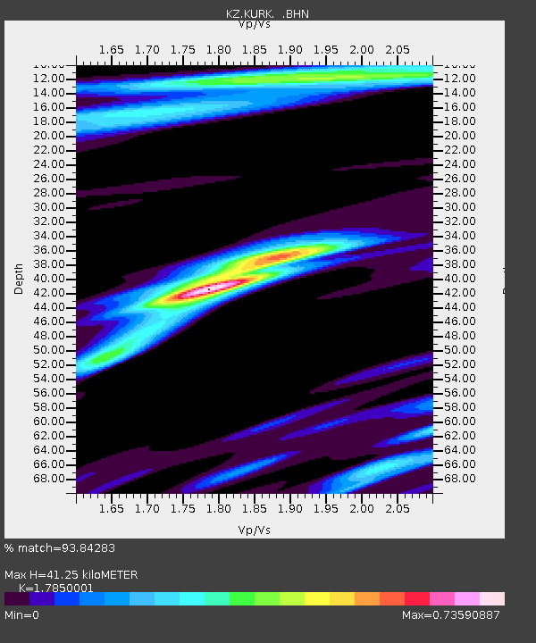
| Estimated Moho Depth: |
41.25 km |
| Estimated Crust Vp/Vs: |
1.79 |
| Assumed Crust Vp: |
6.552 km/s |
| Estimated Crust Vs: |
3.671 km/s |
| Estimated Crust Poisson's Ratio: |
0.27 |
|
| Radial Match: |
93.84283 % |
| Radial Bump: |
394 |
| Transverse Match: |
68.74104 % |
| Transverse Bump: |
400 |
| SOD ConfigId: |
20082 |
| Insert Time: |
2010-03-09 09:31:59.009 +0000 |
| GWidth: |
2.5 |
| Max Bumps: |
400 |
| Tol: |
0.001 |
|

Signal To Noise
| Channel | StoN | STA | LTA |
| KZ:KURK: :BHN:20010918T02:30:08.065024Z | 4.104412 | 2.6614129E-7 | 6.484273E-8 |
| KZ:KURK: :BHE:20010918T02:30:08.06301Z | 5.7481074 | 2.9948995E-7 | 5.2102358E-8 |
| KZ:KURK: :BHZ:20010918T02:30:08.065024Z | 12.068133 | 1.2965326E-6 | 1.0743439E-7 |
| Arrivals |
| Ps | 5.1 SECOND |
| PpPs | 17 SECOND |
| PsPs/PpSs | 22 SECOND |


