You are here: Home > Network List > GS - US Geological Survey Networks Stations List
> Station KAN09 Caldwell North Station > Earthquake Result Viewer
KAN09 Caldwell North Station - Earthquake Result Viewer
| Earthquake location: |
Near Coast Of Northern Chile |
| Earthquake latitude/longitude: |
-24.9/-70.2 |
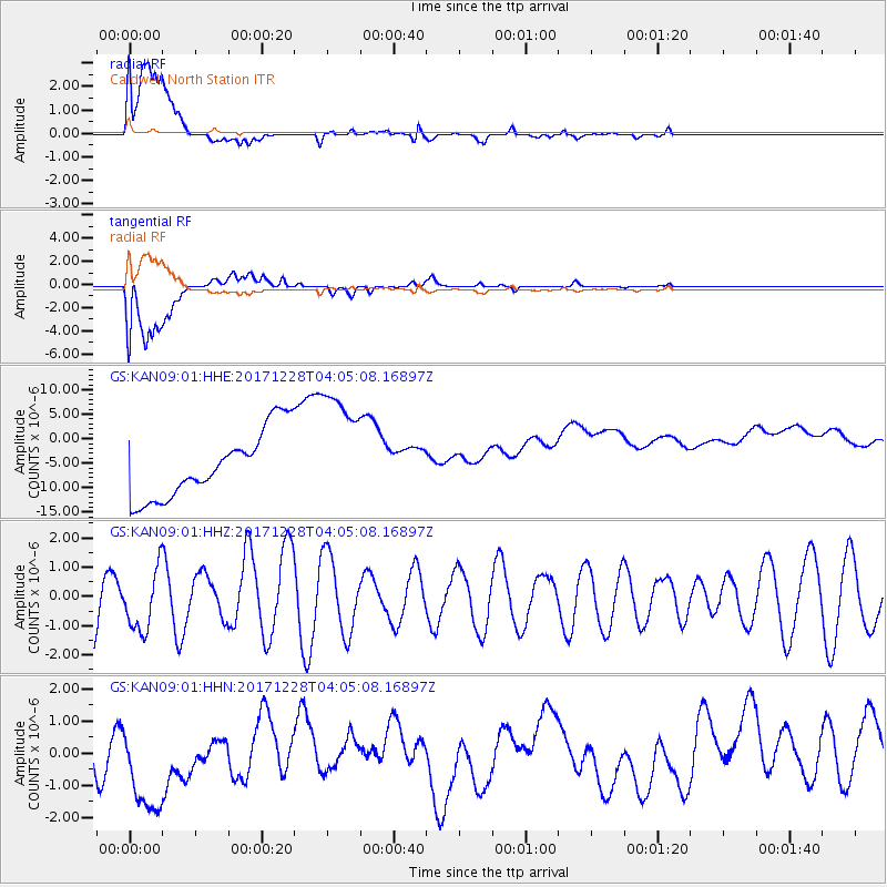
| Earthquake time(UTC): |
2017/12/28 (362) 03:54:52 GMT |
| Earthquake Depth: |
53 km |
| Earthquake Magnitude: |
5.5 Mww |
| Earthquake Catalog/Contributor: |
NEIC PDE/us |
|
| Network: |
GS US Geological Survey Networks |
| Station: |
KAN09 Caldwell North Station |
| Lat/Lon: |
37.14 N/97.62 W |
| Elevation: |
371 m |
|
| Distance: |
66.9 deg |
| Az: |
336.399 deg |
| Baz: |
152.937 deg |
| Ray Param: |
0.057201695 |
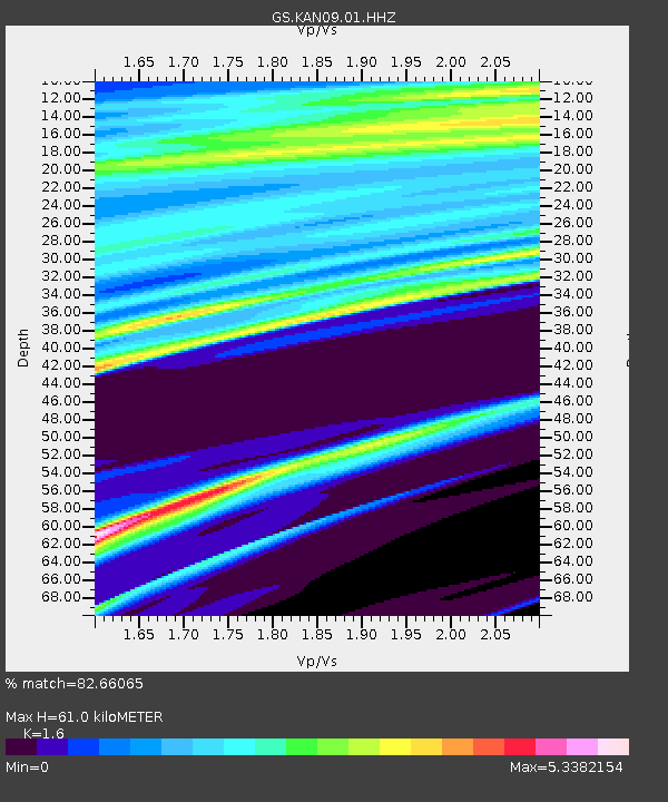
| Estimated Moho Depth: |
61.0 km |
| Estimated Crust Vp/Vs: |
1.60 |
| Assumed Crust Vp: |
6.483 km/s |
| Estimated Crust Vs: |
4.052 km/s |
| Estimated Crust Poisson's Ratio: |
0.18 |
|
| Radial Match: |
82.66065 % |
| Radial Bump: |
400 |
| Transverse Match: |
80.50469 % |
| Transverse Bump: |
400 |
| SOD ConfigId: |
2528331 |
| Insert Time: |
2018-01-11 03:57:17.434 +0000 |
| GWidth: |
2.5 |
| Max Bumps: |
400 |
| Tol: |
0.001 |
|
Signal To Noise
| Channel | StoN | STA | LTA |
| GS:KAN09:01:HHZ:20171228T04:05:08.16897Z | 0.8083403 | 1.0578974E-6 | 1.3087277E-6 |
| GS:KAN09:01:HHN:20171228T04:05:08.16897Z | 1.8750443 | 1.9536758E-6 | 1.0419359E-6 |
| GS:KAN09:01:HHE:20171228T04:05:08.16897Z | 1.8264431 | 1.2453018E-5 | 6.8181803E-6 |
| Arrivals |
| Ps | 5.9 SECOND |
| PpPs | 23 SECOND |
| PsPs/PpSs | 29 SECOND |


