You are here: Home > Network List > IW - Intermountain West Stations List
> Station MOOW Moose Ponds, Wyoming, USA > Earthquake Result Viewer
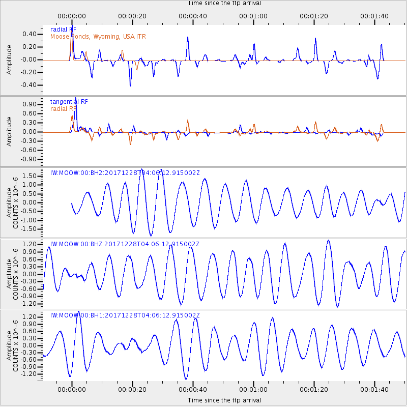
MOOW Moose Ponds, Wyoming, USA - Earthquake Result Viewer
*The percent match for this event was below the threshold and hence no stack was calculated.
| Earthquake location: |
Near Coast Of Northern Chile |
| Earthquake latitude/longitude: |
-24.9/-70.2 |
| Earthquake time(UTC): |
2017/12/28 (362) 03:54:52 GMT |
| Earthquake Depth: |
53 km |
| Earthquake Magnitude: |
5.5 Mww |
| Earthquake Catalog/Contributor: |
NEIC PDE/us |
|
| Network: |
IW Intermountain West |
| Station: |
MOOW Moose Ponds, Wyoming, USA |
| Lat/Lon: |
43.75 N/110.74 W |
| Elevation: |
2128 m |
|
| Distance: |
77.8 deg |
| Az: |
331.172 deg |
| Baz: |
142.825 deg |
| Ray Param: |
$rayparam |
*The percent match for this event was below the threshold and hence was not used in the summary stack. |
|
| Radial Match: |
72.960106 % |
| Radial Bump: |
400 |
| Transverse Match: |
92.50919 % |
| Transverse Bump: |
284 |
| SOD ConfigId: |
2528331 |
| Insert Time: |
2018-01-11 03:58:04.329 +0000 |
| GWidth: |
2.5 |
| Max Bumps: |
400 |
| Tol: |
0.001 |
|
Signal To Noise
| Channel | StoN | STA | LTA |
| IW:MOOW:00:BHZ:20171228T04:06:12.915002Z | 0.10305955 | 1.2019488E-7 | 1.1662663E-6 |
| IW:MOOW:00:BH1:20171228T04:06:12.915002Z | 1.0814033 | 9.726929E-7 | 8.994728E-7 |
| IW:MOOW:00:BH2:20171228T04:06:12.915002Z | 1.576938 | 1.2859774E-6 | 8.154901E-7 |
| Arrivals |
| Ps | |
| PpPs | |
| PsPs/PpSs | |


