You are here: Home > Network List > US - United States National Seismic Network Stations List
> Station HAWA Hanford, Washington, USA > Earthquake Result Viewer
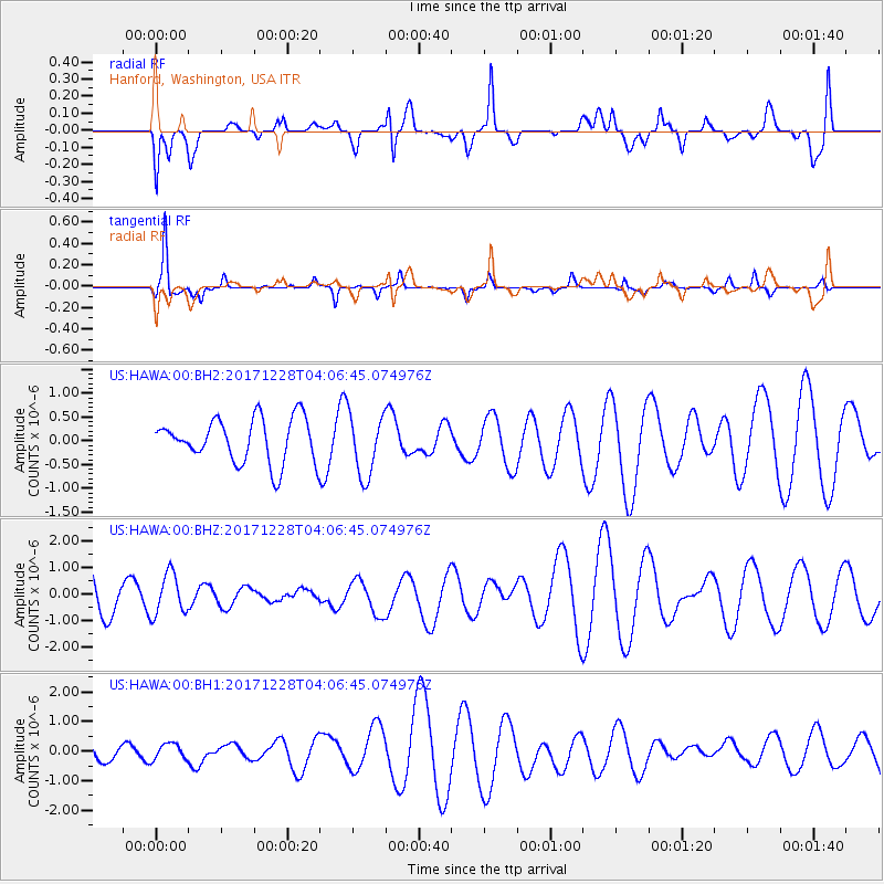
HAWA Hanford, Washington, USA - Earthquake Result Viewer
*The percent match for this event was below the threshold and hence no stack was calculated.
| Earthquake location: |
Near Coast Of Northern Chile |
| Earthquake latitude/longitude: |
-24.9/-70.2 |
| Earthquake time(UTC): |
2017/12/28 (362) 03:54:52 GMT |
| Earthquake Depth: |
53 km |
| Earthquake Magnitude: |
5.5 Mww |
| Earthquake Catalog/Contributor: |
NEIC PDE/us |
|
| Network: |
US United States National Seismic Network |
| Station: |
HAWA Hanford, Washington, USA |
| Lat/Lon: |
46.39 N/119.53 W |
| Elevation: |
364 m |
|
| Distance: |
83.8 deg |
| Az: |
328.117 deg |
| Baz: |
136.128 deg |
| Ray Param: |
$rayparam |
*The percent match for this event was below the threshold and hence was not used in the summary stack. |
|
| Radial Match: |
59.13867 % |
| Radial Bump: |
393 |
| Transverse Match: |
72.048294 % |
| Transverse Bump: |
314 |
| SOD ConfigId: |
2528331 |
| Insert Time: |
2018-01-11 03:59:30.227 +0000 |
| GWidth: |
2.5 |
| Max Bumps: |
400 |
| Tol: |
0.001 |
|
Signal To Noise
| Channel | StoN | STA | LTA |
| US:HAWA:00:BHZ:20171228T04:06:45.074976Z | 1.2859101 | 7.70589E-7 | 5.992557E-7 |
| US:HAWA:00:BH1:20171228T04:06:45.074976Z | 0.87696755 | 2.9720772E-7 | 3.389039E-7 |
| US:HAWA:00:BH2:20171228T04:06:45.074976Z | 1.4148477 | 6.539135E-7 | 4.6217943E-7 |
| Arrivals |
| Ps | |
| PpPs | |
| PsPs/PpSs | |


